 |
Home About Directory Conservation |
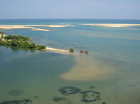 |
Batticaloa Estuary Location: 70 58’ 0 N and 810 29’ 0 E to 70 20’ 0 N and 810 52’ 0 E; 880644 N and 553268 E to 810690 N and 595658 E; in the Eastern Province. More than 90% of the lagoon is located in the Batticaloa District while the southern end is located within the Ampara District Area: 11,500 ha Altitude: Sea level Overview: Encompassing two Districts, the Batticaloa estuary is the third largest brackish water system in Sri Lanka and is connected to the sea at two points. The wetland is highly productive for fisheries, and rich in biodiversity. Extensive mangroves are found around the estuary while extensive segrass beds are also a feature of the estuary. Numerous areas of freshwater swamps are also found along with dry scrublands. More than 10,000 families depend on the lagoon fishery for livelihoods and food security. The estuary also served as an important seaport for trade during the 19th century. Habitat degradation, pollution and land reclamation are threatening the biodiversity and hydrological functions of the estuary. Physical features: The estuary stretches 56 km from north to south with a maximum width of 4 km. The water body shows the characteristic features of a bar built estuary, indicating a high rate of siltation. It opens to the sea via two narrow channels during the wet season when the tidal amplitude is about 10 cm. The salinity varies from nearly 40 ppt near the mouth in some seasons, to 0 ppt in locations furthest from the mouth and close to freshwater sources. Generally, the northern half of the estuary is more saline than the south, and there appears to be two distinct sections separated by a constricted area less than 200 m wide near Kaluvanchikudiyiruppu village. The causeway at Koddaikallar also forms a barrier for freshwater and brackish water exchange. The estuary is located within the dry zone of Sri Lanka, which has a hot and humid tropical climate. The mean annual temperature is 27.40C, although temperature may vary from 180C on cooler nights during the rainy seasons to 380C during the day in May. It receives about 1500 mm of rain annually, mainly during the northeast monsoon from October to February. Freshwater input is received from 19 tanks, 5 major lakes, 11 rivers and streams, as well as numerous irrigational channels belonging to the Mahaweli development areas. Ecological features: There are around 321 ha of mangroves fringing the estuary, and the best mangroves are found near Mattakkali and Pankudaweli where species such as Rhizophora apiculata, R. mucronata, Sonneratia ovalis, Dolichandrone spathacea, Bruguiera gymnorrhiza, Avicennia officinalis and Cerbera manghas are found. Large areas that formerly had well-developed mangroves are now dominated by secondary scrubby mangroves such as Acrostichum aureum along with small trees such as Cerbera manghas, Clerodendron inerme and Exoecaria agallocha. Open areas are dominated by saltmarsh species such as Sesuvium portulacastrum and Suaeda maritima. Extensive seagrass beds dominated by Enhalus and Halophila can be found throughout the northern part of the estuary, which is more brackish. There are large expanses of freshwater swamp in the southern end of the estuary, dominated by invasive Eichhornia crassipes and Salvinia molesta along with a multitude of freshwater species such as Alternanthera sessilis, Azolla pinnata, Ceratophyllum demersum, etc. Around 65 bird species have been recorded from the wetland. Noteworthy fauna: Invertebrates that are important for food such as Penaeus monodon, P. indicus, P. semisulcatus, Metapenaeus dobsoni, M. ensis, Scylla serrata and Portunus pelagicus are found in the estuary. Introduced fish species such as Oreochromis mossambicus and Oreochromis niloticus are common and make up a major part of the fish caught in the estuary fisheries. Other noteworthy fish species include Etroplus suratensis and E. maculates. Threatened birds such as Leptoptilus javanicus and Pelecanus philippensis, and threatened reptiles such as Crocodylus palustris are also found in the estuary. Noteworthy flora: Information not available Land use: The northern part of the estuary supports an extensive shellfish fishery, while fishing for finfish and crustaceans is carried out throughout the estuary. The eastern bank of the estuary is densely inhabited, while the western borders encompass extensive irrigated paddy fields. Several larger islands in the estuary (e.g. Buffalo Island) are used for rice cultivation and a few aquaculture ponds have been constructed near Urani and Kattankudy. Freshwater in the southern part of the estuary is used for irrigation of agricultural lands. Possible changes in land use: Due to the prevailing civil unrest, it is possible that the fisheries and agricultural activities will decrease. The total population of the divisions that border Batticaloa has increased 84% from 1971 to 1999, and such increases in human population may also lead to increased reclamation of wetland areas for settlements. Expansion of aquaculture including shrimp farms is also a possibility. Hydrological and biophysical values: The wetlands are important for flood prevention, and the sandbar across the northern outlet is opened when the water level inside the estuary becomes too high during the monsoon season. During this period, marine finfish and crustaceans migrate into the estuary, replenishing fish stocks through a natural cycle. The estuary also acts as a sink for nutrients, particularly from agricultural run-off. Social and cultural values: The local economy is mainly based on agriculture and fisheries and many families depend on natural resources of the estuary for livelihoods and food security. The waterways of the estuary were once the main mode of transport for local people until the Kottamunai, Kalladi and Valayaravu bridges were constructed, and the estuary also served as the main seaport for trade during the 19th century. In addition, there are numerous historical and important cultural sites nearby, such as the Kannaki Amman Kovil and the Dutch Fort at Puliyantivu that dates back to 1680. Scientific research and monitoring: NARA and the Eastern University have conducted several studies on the estuary. Currently, the department of geography of the SAI is carrying research on community-based resource use and conflict transformation in fisheries. Conservation education: Information not available Recreation and tourism: Batticaloa was a relatively popular tourist destination prior to the civil unrest, the estuary was an important scenic location, and was also used for activities such as bird watching, fishing and boating. However, tourism has currently declined due to the conflict. Conservation measures taken: One of the first conservation initiatives was the development of an Environmental Profile of the Batticaloa District by the CEA in 1993. In 2002, the estuary was declared a FMA under section 31 of the FARA. Under the ADB funded NECCDEP, numerous activities such as fisheries and aquaculture development, promotion of eco-tourism, mangrove replanting, improvement of sanitation infrastructure, development of sanitary solid waste disposal facilities, and improvement of causeway flow are being undertaken. In 2005, a USAID project cleared tsunami debris from the estuary with the assistance of the Sri Lanka Navy. Conservation measures proposed: Several proposals have been made to develop and manage fisheries and aquaculture, improve and develop alternate livelihoods, restore mangrove habitats, and improve sanitation and waste management under the ADB funded NECCDEP. Batticaloa estuary has also been proposed as a SAM site by the CCD. Disturbance and threats: The mangrove cover has declined from 1,490 ha to 321 ha during a 20-year period due to infrastructure development, construction of aquaculture ponds and more recently due to security reasons. The estuary has become a dumping ground for domestic and municipal wastes as well as untreated effluents from industries such as rice mills, dying and shrimp farming, and frequent algal blooms due to eutrophication and resulting fish kills have been reported. During the 2004 tsunami, the estuary was inundated with debris and silt. In some places, the flow and exchange of water within the estuary is impeded by causeways with culverts of insufficient capacity. Spread of invasive alien species such as Parthenium hysterophorus, Eichhornia crassipes and Salvinia molesta is also becoming problematic in the area. Land tenure: The lagoon is state owned, while the adjoining areas are privately owned. Management authority and jurisdication: DFAR and relevant DS References: ARCADIS Euroconsult (2003c); Arulananthan (2002); The Government of Sri Lanka (2003); Jayasingham (2000); Kotagama et al. (1989b); Vinobaba (1999) |
| Maps |