 |
Home About Directory Conservation |
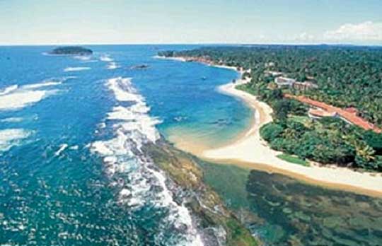 |
Bentota Estuary Location: 60 27’ 0 N and 800 0’ 0 E to 60 22’ 0 N and 800 E 5’ 0 E; 713057 N and 389419 E to 703827 N and 398619 E; south of Aluthgama, within the Kalutara and Galle Districts, of the Western and Southern Provinces respectively. Area: 1,700 ha. Altitude: 5m Overview: This wetland site is made up of the Kahagalla Estuary, canals and marshes, thus, over its range it varies from brackish water to freshwater. Physical features: The funnel-shaped river mouth is a result of the daily tidal movements and the prevailing northerly sea current that forms a long sand spit at the sea outfall. The wetland complex is located in the wet zone of Sri Lanka and experiences an annual rainfall of 2500-3000mm. Most rain is received during April-June and October-November. The average monthly temperature ranges between 26-29oc, while the average monthly humidity is approximately 79% with very little variation during the year. Ecological features: The vegetation types along the river include riverine mangroves (Bruguiera- Rhizophora-Sonneratia- Acrosticum community and Nypa fruticans assemblages), bank scrub and lentic macrophytic assemblages (consisting of submerged and floating vegetation). The vegetation types along the river-land perpendicular gradient include mangrove, mangrove-mixed swamps and the invasive Wormia suffruticosa and Annona glabra stands. Abandoned paddy fields and peat bogs are also found in the border of the estuary. The vertebrate fauna documented from the estuary include 159 species, including 12 endemic species. Noteworthy fauna: Among the freshwater fish recorded, Esomus thermoicos, Rasboroides vaterifloris, Aplocheilus dayi, Puntius singhala and Clarias brachysoma are endemic. The most common amphibians in the mangrove include Euphlyctis hexadactyla and Limnonectes limnocharis. Among the reptiles recorded, Varanus salvator is fairly common. The presence of two largest endangered reptiles - Python molurus and Crocodylus porosus is of conservation significance. The aquatic birds include herons and egrets (Butorides striatus, Dupetor flavicollis, Nycticorax nycticorax, Ardea purpurea, Mesophoyx intermedia), waterfowl (Dendrocygna javanica), Kingfishers (Pelargopsis capensis, Alcedo atthis), large water birds (Threskiornis melanocephalus, Anastomus oscitans), and raptors (Haliaeetus nipalensis, Haliaster Indus). The mammals inhabiting the mangrove include the endemic Trachypithecus vetulus and Moschiola kathygre, while the rare Prionailurus viverrinus and Lutra lutra are also present. Noteworthy flora: The well-developed riverine mangroves in the estuary are dominated by the Bruguiera sexangula, Rhizophora apiculata, and Sonneratia caseolaris community. Bank scrub formations consist mainly of Pandanus spp., Hibiscus tiliaceous and the tall reeds such as Phragmites karka. The mangrove mixed swamps consist of Sonneratia caseolaris, Cerbera manghas, Syzygium spp., Acrosticum aureum, Acanthus ilicifolius, Cyperus spp., and Fimbristylis spp. Lianas or climbers such as Flagellaria indica and Lygodium microphyllum can be seen entangled in the trees from top to bottom. Land use: The estuary is primarily used for fisheries and sedge cultivation for mat weaving. The mangrove stands are exploited for timber and other purposes. This area is also extensively used by the tourism and recreation industry. Possible changes in land use: Increased mangrove deforestation for livelihood purposes and increased land reclamation in this area for development are major forms of land use change. Additionally, the area has been identified as a tourism development zone which could lead to an increase in land reclamation and tourism activities. Hydrological and biophysical values: Information not available Social and cultural values: This area comprises of a number of historical and cultural sites of interest. One such site is the Galapatha Vihare temple constructed by King Devanampiyatissa during the Anuradhapura era. Other temples of interest are the Vanawasa Vihare temple, Bodimaluwa temple, Ben Vehera and Bodhi Samipa Viharaya Scientific research and monitoring: Occasional surveys have been conducted by conservation organisations and academic institutions. Conservation education: Information not available Recreation and tourism: Activities such as kayaking, boat rides and windsurfing are organised by hotels and water sports centres. Conservation measures taken: The CEA produced a wetland site report and conservation management plan in 1994. Honduwa island located within the estuary has been declared as a sanctuary under the FFPO. Conservation measures proposed: The wetland site report prepared by the CEA has recommended a conservation management plan for the area. This site is listed as a proposed SAM site by the CCD. Other conservation measures that have been proposed include, conducting regular biodiversity surveys, placing regulations on mangrove exploitation,establishment of a fisheries society that can monitor fishing gear used within the wetland, control of pollution and regulation of tourism activities. Disturbance and threats: Invasive alien plant species such as Annona glabra and Wormia suffruticosa have invaded the mangrove and marshy areas forming uniform stands. In addition, anthropogenic activities such as land reclamation, pollution and mangrove deforestation are prevalent. Land tenure: The majority of the land is state-owned while some land around the estuary mouth is privately owned. Management authority and jurisdication: Honduwa Island Sanctuary is under the management jurisdiction of the DWC. References: Bambaradeniya et al. (2006); CEA/ARCADIS Euroconsult (1994d) |
| Maps |