 |
Home About Directory Conservation |
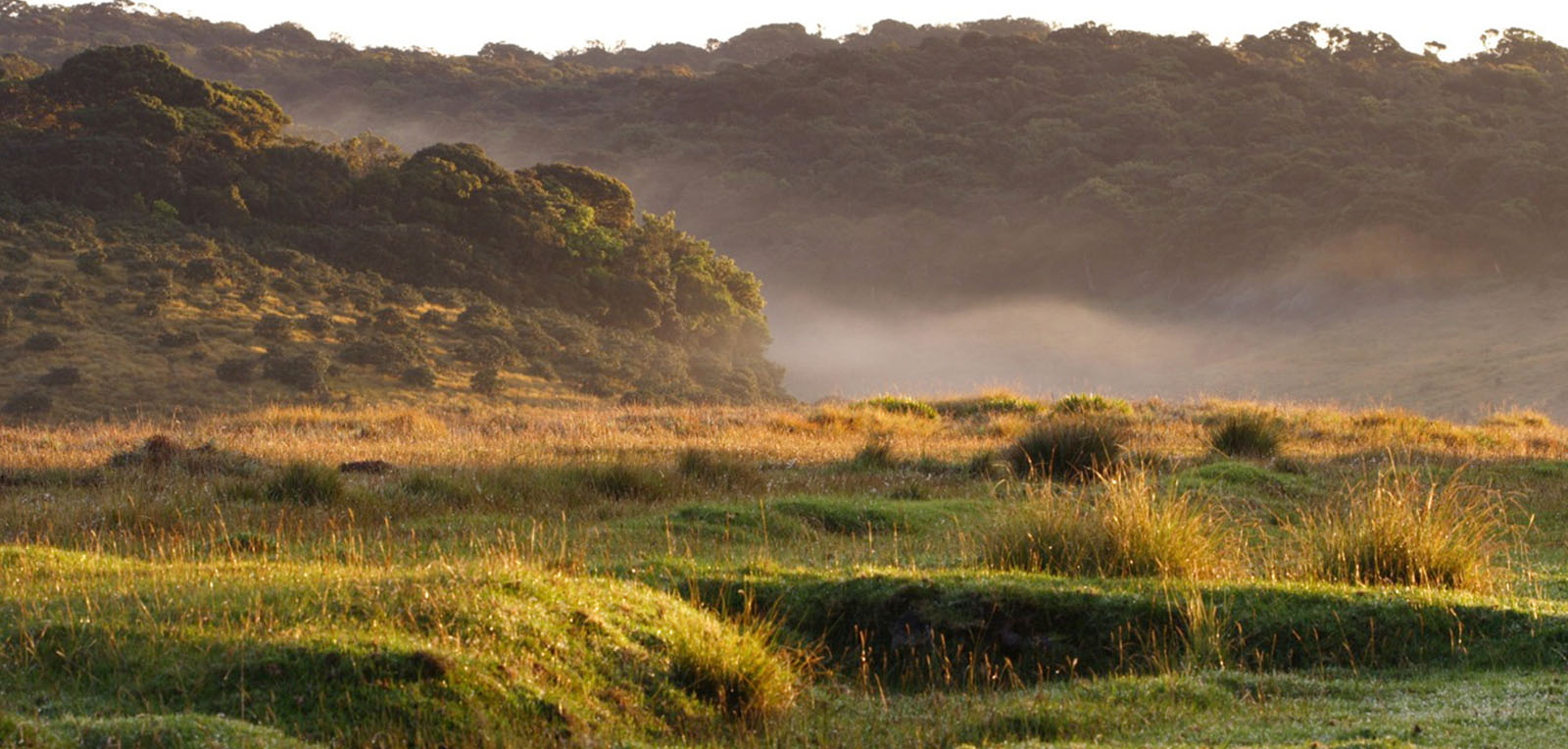 |
Horton Plains National Park Location: 60 51’ 15 N and 800 45’ 30 E to 60 45’ 0 N and 800 50’ 30 E; 75174 N and 472378 E to 746116 N and 481582 E; about 32 km south of Nuwara Eliya town in the Nuwara Eliya District, of the Central Province. Area: The National Park is 3,160 ha in extent and is contiguous with the eastern part of the Peak Wilderness Sanctuary. Altitude: 1,200 – 2,300 m Overview: The area contains the largest single extent of wet montane patana grasslands and montane dwarf-forests in Sri Lanka. Horton Plains is regarded as one of the most important water catchment areas in the country as the lower part of the grassland is important for collection and storage of the headwaters of a number of important rivers such as the Mahaweli, Walawe and Kelani. Slow flowing streams, waterlogged swamps and waterfalls are the prominent wetland types. The area is rich in biodiversity with high endemicity. Horton Plains National Park (HPNP) is also a popular tourist destination in Sri Lanka. Physical features: The HPNP is located on the southern plateau of the central hills. It is dominated by Mount Totupolakanda (2,357m) to the north and by Mount Kirigalpotta (2,389m) to the west, which are Sri Lanka’s third and second highest peaks respectively. The Precambrian rocks found in this area belong to a Highland series and consist mainly of granite rocks. The soil is of the red-yellow podsolic group while a thick black layer of decayed and decaying leaf and plant matter covers the surface layer. The mean annual rainfall is over 2000 mm, while high humidity and frequent cloud cover limits the amount of sunlight reaching the plants. The temperature can vary from highs of up to 270C during the day to less than 50C during the night. Strong winds are common during the southwest monsoon period and can sometimes reach gale force strengths. Ecological features: The vegetation cover can be divided into two distinct regions of which 2,000 ha consists of wet patana and the balance 1,160 ha is covered with sub-tropical montane evergreen forests. 744 plant species distributed among 20 families have been recorded. The grasslands are plagioclimax communities characterized by frequent fire and grazing. The grasslands are dominated by Arundinella villosa and Chrysopogon zeylanicus. Wet or water logged swamps and slow flowing streams can be found between knolls and depressions. Submerged aquatic macrophytes like Aponogeton jacobsonii the sedge Isolopis fluitans and a bladderwort Utricularia spp. are found in the slow flowing streams of Horton Plains. The bamboo Arundinaria densifolia exists along most of the stream banks. In waterlogged depressions and swampy areas Juncus primatocarpus, Garnotia mutica, Eriocaulon spp. and Exacum trinervium are common species. Twenty four species of mammals, 87 species of birds, 9 species of reptiles and 8 species of amphibians have been recorded. Noteworthy fauna: Only two exotic fish species inhabit the streams; Cyprinus carpio and Oncorhynchus mykiss. The streams harbour many species of endemic crustaceans, including Caridina singhalensis, and Perbrinkia spp. Endemic amphibians associated with the streams include Polypedates eques, P. longinasus, Limnonectes greenii, Lankanectes corrugata, and Microhyla zeylanica. Among the birds, the endemic Myophonus blighi and Gallus lafayetti visits the edges of streams and ponds, while the raptors Circus spp. visits the wetlands during the migratory season. A large herd of Cervus unicolor occurs in the park, while Prionailurus viverrinus and Lutra lutra visit the wetlands for feeding on aquatic organisms. Noteworthy flora: Notable plant species in the park includes endemic trees such as Calophyllum walkeri, Rhododendron zeylanicum, shrubs such as Rhodomyrtus parviflora, Gaultheria fragrantissima, herbs such as Exacum trinervium and E. walkeri, Drosera indica, and Giant ferns (Cyathea spp.). Land use: The HPNP is mainly surrounded by a forest reservation which is under the control of the Forest Department, while two tea estates exist at Diyagama and Ginihiriya. Individuals from the peripheral villages collect timber, fuelwood and herbal plants and use the park area as a grazing ground for their livestock. Possible changes in land use: Increased demand for natural resources could lead to an increase in the use of the park for human uses such as collection of firewood and livestock grazing Hydrological and biophysical values: Horton Plains is the most important watershed of the country and serves as an important catchment area for the Mahaweli Ganga, Walawe Ganga, and Kelani Ganga. Due to its elevation, there is substantial moisture content in the land as a result of fog interception and cloud deposition. This additional contribution comprises about 25 percent of the total precipitation. However, most of this additional moisture escapes back into the atmosphere as evaporation from the canopy. Social and cultural values: Recent studies have discovered pre-historic stone tools dating back to the Balangoda culture, indicating that Horton Plains is one of the most significant pre-historic human settlements in the country. Scientific research and monitoring: The University of Peradeniya and the Institute of Fundamental Science at Hantane have carried out several research projects, especially on forest die-back and water quality. Conservation education: A visitor centre located in the park provides information on the biodiversity and conservation of the important montane ecosystems. Additionally, the DWC conducts programmes on waste management within the park area. Recreation and tourism: Horton Plains is a very popular tourist destination, with the main attraction being Worlds End. The beauty of the landscape, the flora and faunal heritage and the opportunities for recreation attract local and foreign tourists in large numbers. There are four bungalows/guest houses in the area. Conservation measures taken: Under British rule, this area received some form of protection under the administrative order issued in 1873, which prohibited clearing and felling of forests above 1,520m. In December 1969, Horton Plains was declared a National Reserve, and subsequently elevated to the status of a National Park in 1988 under the FFPO. The CEA produced a wetland site report and conservation management plan for this site in 1995. Under the ADB funded PAM project, a management plan for the park was developed in 2005. Conservation measures proposed: The 2005 management plan identifies the following activities: Diversion of the public road, strengthening law enforcement, prevention of illegal gem mining and rehabilitation of mined pits, establishment of trekking trails with suitable interpretation points, establishment of a montane conservation education center, habitat management and improvement, demarcation of boundaries and their maintenance and improved coordination with the Forest Department. Other measures have been listed in the conservation management plan produced by the CEA. Disturbance and threats: Problems associated with tourism such as removal of plants, littering, fires, off-road driving and walking, and noise pollution are some of the major issues within the popular areas of the park. Other threats and disturbances include illegal gem mining and timber felling (particularly from the forest reservation) and collection of plants for ornamental and medicinal purposes, encroachment, poaching and movement of vehicles along the pubic road at night. The spread of invasive alien species such as Ulex europeus, Pteredium spp. and Pennisetum spp. is threatening native plant species. The carnivorous Oncorhynchus mykiss may have affected the populations of endemic aquatic organisms such as amphibians and crustaceans. Progressive dieback of forest has affected 22 plant species, with Calophyllum walkeri being the most affected. Land tenure: State owned Management authority and jurisdication: DWC, while the adjoining forest reservation is under the jurisdiction of the Forest Department References: CEA/ARCADIS Euroconsult (1995c); DWC (2004); DWC (2005a); Gunawardena (2000) |
| Maps |