 |
Home About Directory Conservation |
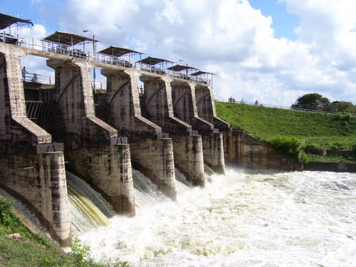 |
Inginimitiya Reservoir Location: 70 57’ 0 N and 800 7’ 0 E to 70 55’ 0 N and 800 10’ 0 E; 878874 N and 402642 E to 875177 N and 408146 E; about 130 km from Colombo, in the Puttalam and Kurunegala Districts, of the North-western Province. Area: 2,041 ha Altitude: Less than 50m msl Overview: Inginimitiya is the largest irrigation reservoir in the Puttalam District and was commissioned in 1985. It facilitates supply of water to 2,551 ha of agricultural land, including new land area of 1,880 ha. The tank was constructed by damming the Mi Oya, aimed at doubling the area under paddy and other staple crop cultivation. However, the performance of the project has been unsatisfactory due to the shortage of water in the reservoir. Physical features: The Mi Oya is the main water source of the water to the reservoir and originates from the Dambulla hills, which are located in the dry zone of Sri Lanka. Due to the shortage of water in the reservoir, only 75% of irrigable land is cultivated successfully during the Maha season. The irrigation reservoir and its catchment area lies within the Kurunegala District in the region that experiences an annual rainfall below 1,500 mm. The command area of the reservoir is in the Puttalam District. Dry spells and absolute droughts are common in the Puttalam District and have recorded between 120 –200 days of drought in some years. Analysis of past rainfall patterns (1956 –1975) indicate highly erratic rainfall, with the annual average varying from 740 mm to 2,210 mm. In recent years it has been around 841 mm per year. The temperature averages around 27oC for the majority of the year. Soils in the area are sandy loam to sandy clay loam, while imperfectly drained soil covers one half of the area. Ecological features: Major wetland habitat types include managed fresh water wetlands (tank, irrigation canals, marshes, paddy lands and streams). Detailed information on ecological features and biodiversity associated with this reservoir is lacking. Noteworthy fauna: Several species of aquatic birds inhabit the reservoir dominated by egrets, herons and cormorants. Noteworthy flora: Tree species such as Terminalia arjuna, Diospyros malabarica and Vitex leucoxylon can be found around the reservoir. Land use: The tank is mainly used for fisheries while its surrounding areas are used for paddy cultivation. Additionally, depending on the availability of water, chillies, Bombay onion, red onion, corn, green gram, cowpea and soya beans are also grown in the area. Livestock farming and brick production are also other land use activities in the reservation area. Possible changes in land use: The Inginimitiya project is facing serious water shortage problems due to prevailing drought conditions in the area. During the past 25-year period, the annual average basin rainfall decreased by 162.5 mm. This has lead to changing crop cultivation patterns. Hydrological and biophysical values: The tank water is used for irrigation purposes. Besides rainwater, the tank is the only source of water supply for paddy cultivation in the downstream areas. Social and cultural values: Some people work at their fields during the day and catch fish at night. Around 25% of the fishermen catch for commercial purposes, while the others catch for personal consumption. Approximately 50% of the people in the surrounding areas consume fish on a daily basis. About 25-30 families raise cattle and buffaloes and some farmers have more than 300 individuals in a herd. There is a large ceremony called the ‘Aluth Sahal Mangalya’ held near the tank after each paddy harvest. Scientific research and monitoring: Information not available Conservation education: Information not available Recreation and tourism: Tourism is mostly restricted to local tourists with approximately 5 vehicles visiting the area per weekend, mainly to view the reservoir and for other recreational purposes including bathing. There are no tourist facilities in the area. Conservation measures taken: Information not available Conservation measures proposed: Information not available Disturbance and threats: Forest clearing, human-elephant conflict, destructive fishing practices and increased salinity in the wells and tank water are major threats in this area. The spread of invasive alien plants such as Salvinia molesta and Eichhornia crassipes is also posing acute problems to the aquatic biodiversity. Agricultural extension services operating in the project area are not effective mainly due to the absence of extension workers. Land tenure: State owned Management authority and jurisdication: The tank area is under the purview of the Irrigation Department while the settlement area is under the Local Government Agency. References: Ministry of Irrigation and Water Management (2002); Murray et al. (unknown); OECF (1993); Vimalachanadran (1994) |
| Maps |