 |
Home About Directory Conservation |
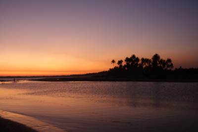 |
Kahandamodara Mangroves Location: 60 7’ 0 N and 800 52’ 0 E to 60 5’ 0 N and 800 57’ 0 E; 676103 N and 485247 E to 672417 N and 494467 E; 212 km south of Colombo, in the Hambantota District, of the Southern Province. Area: 215 ha Altitude: Sea level Overview: Kahanda estuary is a branched shallow wetland with a few mangrove islands, comprising 215 ha of mangrove forest. The estuary opens to the sea through a narrow canal on the southern side and is rich in mangrove species. The consistently high water level has contributed to protect the dense mangrove vegetation around the estuary from human exploitation. Physical features: The coastal plain has been formed primarily through the erosion of crystalline rocks, and extensive recent sedimentary deposits. Kahanda is located in the dry zone, and receives most of the rainfall from the northeast monsoons, with an annual rainfall of between 1,000–1,250 mm. The average temperature is around 26.60C–27.20C. The estuary receives fresh water mainly from the Ranna Oya, which is connected to the Urubokka Oya that has been developed and successfully utilised for irrigation of paddy land. The coastal area has rocky and sandstone habitats that shield the estuarine delta of Kahandamodara. Ecological features: The shallow and branched estuary has facilitated the establishment of a mangrove community harbouring a diversity of plants and about 12 mangrove species have been recorded from the area. There is a preponderance of Nypa fruticans compared with the nearby (6 km away) Rekawa lagoon, where this species is very sparse. At least 20 species of fish have been recorded from the estuary, which includes fresh water and brackish water forms. Noteworthy fauna: The mangroves provide refuge for mammals such as the endemic Macaca sinica, and two rare cat species (Prionailurus viverrina and P. rubiginosus). Among the reptiles, Varanus salvator is common in the estuary. Two species of endemic amphibians (Rana gracilis and Limnonectes keertisinghei) can be found in this area. The dense mangrove vegetation and branched estuary has made this wetland an ideal nesting and feeding habitat of water birds such as herons (i.e. Ardeola grayii, Ardea cinerea, Nycticorax nycticorax) egrets (i.e. Mesophoyx intermedia, Egretta garzetta) and bitterns (Ixobrychus cinnamomeus. I. sinensis). Noteworthy flora: The mangrove in Kahanda is noted for the abundance of Nypa fruticans stands. Other woody mangrove vegetation includes Avicennia officinalis, Dolichandrone spathaceae, Lumnitzera racemosa, Excoecaria agallocha, Aegiceras corniculatum, Sonneratia caseolaris, Heretiera littoralis and Bruguiera sexangula. Cassine glauca is the only endemic species found in this area. Among the plants that occur in mangroves of the southern coast, Ardisia willisii, Cerbera odollam, Nypa fruticans, Barringtonia racemosa, Bruguiera sexangula, Mimusops elengi and Sapium indicum is restricted to the Kahanda estuary area. Land use: The wetland and its surroundings are used for fisheries, human settlements and the establishment of tourist guesthouses and cabanas. The opening of the estuary is used for bathing and washing. Possible changes in land use: There is a plan to develop prawn farms in the area, which can be a major threat to the future survival of mangroves. There is also a possibility of potential discharge of industrial effluents from the Bata-atha Industrial complex in the future. Hydrological and biophysical values: The Kahanda estuary is important for flood control. It is also part of a continuous system of wetlands encompassing the Tangalle and Hambantota Districts. Social and cultural values: There are about 225 families residing in the area who, due to the levels of poverty in the area, depend highly on the mangrove resources for food and livelihoods. The mangal areas are utilized to extract clay for the brick industry, Nypa fronds for thatching, Pandanus leaves for weaving and Acrostichum ferns for food. Some villagers are employed in lagoon fisheries especially during the monsoon periods. The coir industry is organised on a small scale. Obeysekararamaya, a Buddhist temple with a 19th century image house is found in the vicinity. Scientific research and monitoring: IUCN has conducted several biodiversity assessments in the area. Conservation education: Some awareness training was provided for selected community members through the GEF funded RUK project. Recreation and tourism: The lagoon is of great scenic beauty but is still relatively unknown among tourists. Conservation measures taken: The Forest Department has identified the area to be protected as a Conservation Forest under the Forest Ordinance. Additionally the Forest Department and IUCN prepared a management plan for 10 selected mangrove sites located south of Colombo, including Kahandamodara. The Hambantota Integrated Coastal Zone Management Plan has also come up with management options for the mangroves and their 101 surrounding environs. Mangrove restoration activities have been implemented by local CBO’s and the Forest Department subsequent to the tsunami. Conservation measures proposed: Information not available Disturbance and threats: Removal of mangroves for firewood and construction of human settlements, including tourist cabanas has degraded critical habitats. The hotels situated close to the lagoon have no proper garbage disposal facilities and garbage disposal can develop into a major threat to this lagoon. Some villages living in Kahanda upper area are involved in illegal gem mining, which has lead to degradation of habitats in these areas. A large tract of mangrove in the eastern border of the estuary, dominated by Heretiera littoralis and Sonneratia caseolaris was destroyed by the Tsunami. Land tenure: The estuary is state owned while surrounding areas are privately owned. Management authority and jurisdication: Tangalle DS References: CCD/IUCN/UNDP (2005); IUCN (2000a); IUCN (2003a); Southern Development Authority of Sri Lanka/ CCD (2000) |
| Maps |