 |
Home About Directory Conservation |
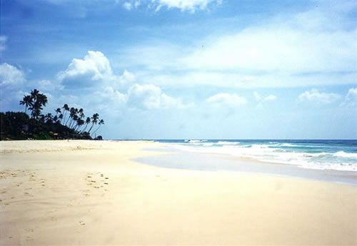 |
Koggala Lagoon Location: 60 20’ 0 N and 800 17’ 0 E to 50 58’ 0 N and 800 22’ 0 E; 700107 N and 420734 E to 659560 N and 429904 E; about 130 km south of Colombo in the Galle District, of the Southern Province. Area: 727 ha Altitude: Information not available Overview: There are 14 islets of varying sizes, forested with mangroves and terrestrial shrubs, within the lagoon. The largest islet is located in the southeast corner of the lagoon near Gurukande Temple. A number of waterways are connected to the Koggala lagoon although its main freshwater source is the Koggala Oya. An increase in salinity levels and water logging has caused large extents of paddy lands around the lagoon to be abandoned. This reduction in potable water sources poses a considerable problem to the local communities. Physical features: The Koggala lagoon has a relatively deeper basin and larger surface area with respect to other coastal water bodies in the southern coast. Its volume is 127x106 m3 and it has a depth range of 1.00m to 3.7m. The lagoon is essentially a rain fed coastal lake. A perennial stream, which drains the northwest portion of the watershed, empties into the lagoon via the village called Godawatte. The main geological form of the area is garnet biotite gneiss of Precambrian origin. The predominant soil types in the area are red yellow podzolic soils with soft or hard lateritic sub soils, which are characteristic of the southwest of the country. The deposition and sedimentation of alluvial and marine deposits can be observed in some areas of the lagoon. Prior to the removal of the natural sand bar at the mouth of the lagoon the salinity fluctuations ranged from 3 % to 15 %. However, once constructions to permanently open the lagoon mouth were introduced, the salinity of the lagoon increased causing an alteration in the species of fish recorded. Since most fish species that were traditionally found in the lagoon were adapted to a fresh water environment, these increased salinity levels have caused a decline in the fish stocks. Koggala is located in the wet zone on the southern coast of Sri Lanka and therefore experiences a mean annual rainfall of between 2,000 to 2,500mm with the heaviest rainfall in the months of May (300 mm) and October (340 mm). It receives rain during the southwest monsoon and during the first and second monsoon periods. The temperature in the area ranges between 15oC and 28oC. Ecological features: Fringing mangrove and scrubland form the main natural vegetation around the lagoon and its islands. Managed vegetation types around the lagoon include home gardens, paddy fields and plantations (rubber, coconut). The islands consist of mangrove as well as non-mangrove plant species. The salinity of the lagoon has increased considerably since 1992, subsequent to the removal of the sand bar across the mouth of the lagoon, which has led to a gradual change in the species composition of mangrove vegetation. Sonneratia caseolaris, which was a common mangrove species in the lagoon, has decreased considerably 124 over the past decade. The increase in salinity has also led to a change in the species composition of aquatic fauna in the lagoon. Noteworthy fauna: This site is important for prawn fisheries (Metapenaeus dobsoni, Penaeus indicus and Macrobrachium rosenbergii). Among the fish present in the lagoon Clarias brachysoma is endemic. Aquatic reptiles in the lagoon include Varanus salvator, Crocodylus porosus, C. palustris, Lissemys punctata, and Melanochelys trijuga. The Python (Python molurus) also occurs in islands covered with dense mangroves. The Koggala beach is a popular nesting area for all five species of marine turtles that visit Sri Lanka. The wetland ecosystem serves as breeding and foraging grounds for herons (Ardeola grayii, Nycticorax nycticorax) egrets (Mesophoyx intermedia, Egretta garzetta), waterfowl (Dendrocygna javanica), kingfishers (Alcedo atthis, Halcyon capensis) and terns (Sterna spp.) that feed on the aquatic organisms. Rare mammals in the area include Lutra lutra, and Prionailurus viverrinus. Noteworthy flora: The dominant fringing mangrove is Rhizophora mucronata while other species found in the area include R. apiculata, Bruguiera sexangula, Sonneratia casiolaris, Acanthus illicifolius, Acrosticum aurium, Avicennia officinalis, A. marina, Aegicerus comiculatum, Excoecaria agallocha, Nypa fruticans and Dolichandrone spatheacia. The lagoon banks are covered with Typha angustifolia, Phragmites australis and Cyperus spp. The endemic terrestrial plant species include Mangifera zeylanica, Artocarpus nobilis and Horsfieldia iryaghedhi. Land use: The wetland and its surrounding areas are mainly used for fisheries, tourism and agriculture (that uses water from the inflow area of the lagoon). Prawn fishing is undertaken at a large scale in the areas close to the lagoon mouth while a small-scale subsistence fishery is also known to be in place. The mangroves are used for house construction, agriculture and firewood. Animal husbandry is also an economic activity in this area. A few patches of coconut plantations are scattered mainly towards the seaward boundary and a fairly large area in the north-eastern part of the watershed bordering the lagoon has been cultivated with cinnamon. The infrastructure development in the watershed is minimal, except for the Free Trade Processing Zone (FTPZ) and establishment of a few tourist hotels along the beach. Possible changes in land use: Rapid tourism development activities around this area could lead to construction of tourism related infrastructure in the islands and areas bordering the lagoon. Hydrological and biophysical values: After the natural sand barrier at the river mouth was removed in 1992 the Southern Provincial Council built a groyne system to avoid sand deposition in the lagoon. However construction of the groyne resulted in the lagoon mouth being permanently open which in turn led to many environmental problems around the lagoon environment. As such in order to control the salinity level that was affecting the paddy cultivation areas, three anicuts and one bund (3km) were constructed by the Irrigation Department. Social and cultural values: There are a number of sites of historical and cultural value (including temples) in the area. One of the islets, Madol Duwa, belongs to the family of Sri Lanka’s renowned writer, Martin Wickramasinghe. Scientific research and monitoring: NARA carried out a study on ‘the effects of saltwater intrusion’ in 2006. Ruhuna University and the Institute of Fundamental Studies have, in the past, carried out water quality studies. A laboratory located within the Koggala Trade Processing Zone routinely monitors the quality of the effluents released through the sea outfall. Conservation education: Information not available Recreation and tourism: Lagoon tours and bird watching trips are conducted particularly to the small islets within the lagoon. Approximately 50-200 local tourists visit per day (mostly on the weekends) including school children, particularly to visit the island Madol Duwa. From December to April this site supports approximately 50-100 foreign tourists per day. There is one hotel on an island and a further four hotels in the vicinity. Sri Lankan air taxi, a domestic service of the Sri Lankan airlines operates seaplane tours to this lagoon. Conservation measures taken: The CEA prepared a wetland site report/conservation management plan for Koggala lagoon in 1995. The reef and surrounding coastal area has been included in the Habaraduwa SAM plan by the CCD to initiate participatory community based management. The CCD has built coast protection structures. Some of the families in the islands grow mangroves around the island to protect it from erosion. This is a proposed EPA under the NEA of the CEA. Conservation measures proposed: Conservation and management recommendations have been listed in the SAM Plan for the area produced by the CCD and the conservation management plan produced by the CEA. Disturbance and threats: The permanent opening of the lagoon mouth by removing the sandbar in 1992 caused a series of problems due to the influx of salt water, which resulted in an increase in the salinity levels of the lagoon and surrounding areas. Some of the problems included the increased sandiness of the lagoon bed due to the influx brought in at high tide, the abandoning of paddy lands, decline in fish productivity in the lagoon and the destruction of some mangrove species particularly Sonneratia caseolaris. Additionally, the high salinity of the lagoon water makes it unsuitable for human consumption and other domestic activities. Fishing practices are also unregulated and thus lead to overexploitation of the valuable resources. The growth of invasive plant species within the lagoon (i.e. Salvinia molesta) has led to a decrease in other species naturally found in the area. The ease with which foreigners are allowed to purchase land has led to large scale clearing of mangroves for construction purposes. Mangroves have also been destroyed due to the discharge of effluents into the lagoon. Unauthorised filling and encroachment of the lagoon boundary and land erosion leading to sedimentation in the lagoon are further threats to the wetland area. The landing of seaplanes in the lagoon is known to affect the bird populations, and cause erosion of the lagoon banks due to the large waves created during landings. Madol Duwa is threatened by irresponsible waste disposal by tourists. Need urgent actions to mitigate existing threats. Land tenure: The lagoon is state owned, while some of the islands are privately owned. Management authority and jurisdication: The CCD has legal jurisdiction over the lagoon under the CCA. References: CCD (2005a); CCD (2006b); CEA/ARCADIS Euroconsult (1995d); Silva (1996) |
| Maps |