 |
Home About Directory Conservation |
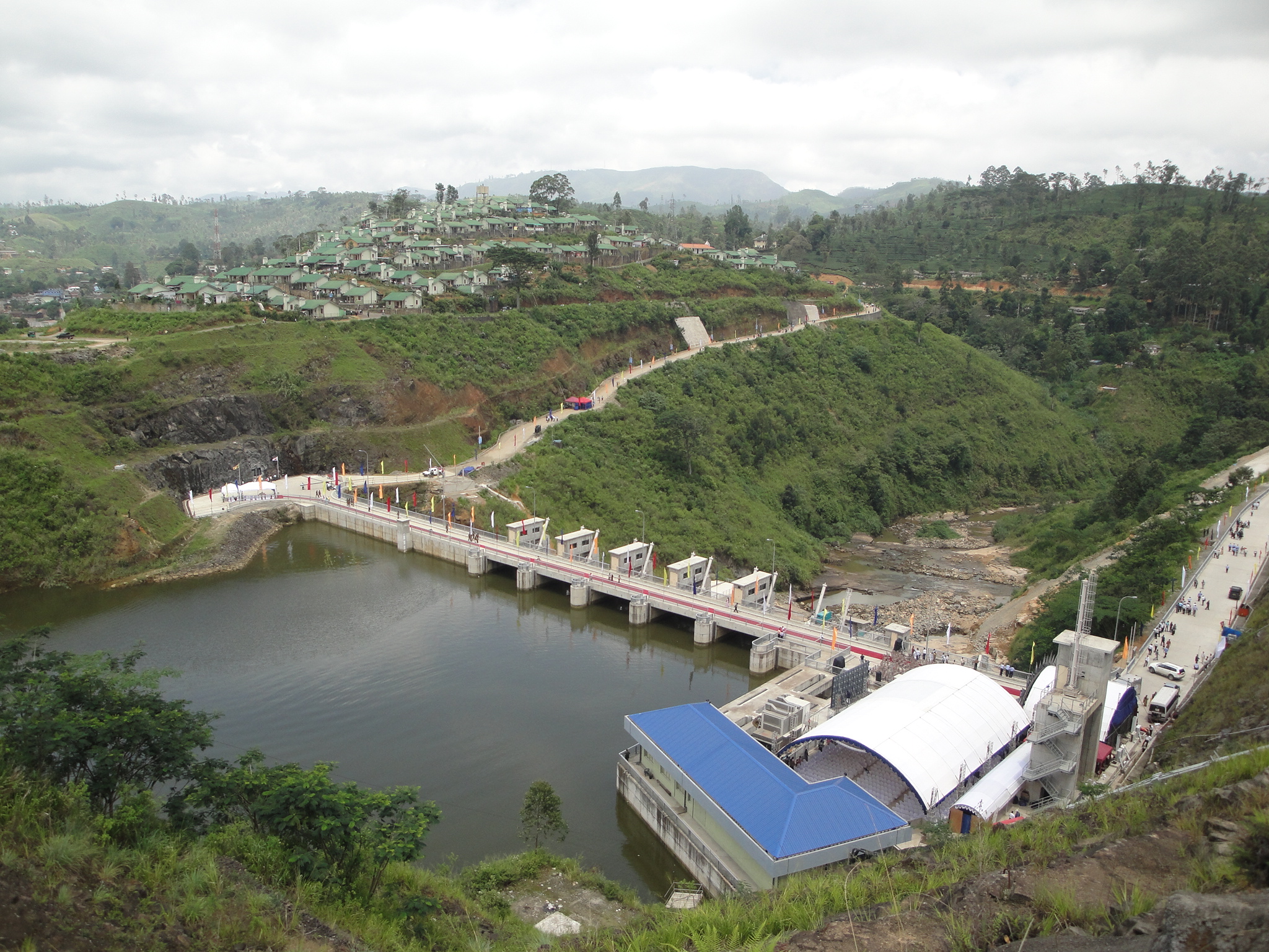 |
Kotmale Reservoir Location: 70 55’ 0 N and 800 35’ 0 E to 70 10’ 0 N and 800 42’ 0 E; 875108 N and 454074 E to 792184 N and 466876 E; lies between the Kandy and Nuwara Eliya Districts in the Central Province. Area: Surface area of the water body 6,500 ha (6.5 km2) Altitude: 703 m at msl. Overview: Kotmale reservoir is the uppermost impoundment of the Mahaweli River, which was constructed in 1985 under the Accelerated Mahaweli Development Programme for hydropower generation. An 87 m high rockfilled dam was built across the Kotmala Oya, which is a main tributary of the Mahaweli, at Kadadora, enabling the regulation of a large proportion of the recorded mean annual flow of the Oya. As an additional benefit, the reservoir increases the amount of irrigation water available at Polgolla and also stabilizes the water supply to the entire reservoir system of the Mahaweli River. During low water periods, the reservoir becomes eutrophic due to the inflow of a large amount of nutrients from its catchment, which comprises mainly of tea plantations. Physical features: The catchment of the reservoir falls within the upcountry wet zone and receives the highest rainfall during the southwest monsoons from May to September. However, large seasonal variations in rainfall can occur and this changed rainfall pattern strongly influences the inflow regime into the impoundment, as there are no lakes or swamps in the catchment to retain the excess water. The gross storage up to full reservoir level is 174 x 106 m3 and the length of the reservoir is 6.8 km. It has a maximum depth of 90 m near the dam, while the mean depth is 26.8 m. The surface temperature of the reservoir water varies between 23 – 30.2oC. Several waterfalls are located in the upper reaches of the reservoir. Ecological features: The environs in the reservoir area can be divided into several ecological units with profound differences in physical and biological conditions: the aquatic environment of the reservoir (including connected streams); the shores/riparian zone; the home gardens and paddy fields of the valley slopes; remnant patches of humid lower and upper montane forests, tea plantations; montane grass lands (patanas) and patches of riverine forest. The slopes along the rim of the reservoir are entirely used for home gardens and rice cultivation. Extensive areas of grassland can be found on the highest hilltops, especially to the north of the reservoir. A dense lower and upper montane forest is present on both sides of the reservoir, which is an important refuge for mammals and birds. About 50% of the catchment is covered by very large tea plantations, which occur at elevations between 1,000–1,500m. The plankton of the reservoir consists of 43 species of phytoplankton, which is dominated by Chlorophyceae and Staurastrum species. The Cyanobacteria, Microcystis aeruginosa is abundant in the upper reaches of the reservoir during periods of low water. The zooplankton community is dominated by rotifers such as Brachionus species. More than 12 species of fish have been recorded from the reservoir. Noteworthy fauna: Important food fish species in the reservoir include three species of exotics (Oreochromis mossambicus Oreochromis niloticus and Cyprinus carpio) and natives such as Tor khudree. Among the aquatic herpetofauna, the endemic Lankanectus corrugata inhabits the streams around the reservoir. The birds are dominated by egrets (Egretta garzetta), herons (Ardeola grayii) and kingfishers (Alcedo atthis, Halcyon smyrnensis), while rare raptors include Elanus caeruleus. Among the mammals, Lutra lutra and Prionailurus viverrinus inhabit the surrounding environs. The reservoir riparian areas and associated streams harbour several endemic crab species (Perbrinkia spp. and Ceylonthelphusa spp.). Noteworthy flora: Some common plant species associated with patches of riverine forests around the reservoir include Artocarpus nobilis, Bambusa vulgaris, Bhesa zeylanica, Caryota urens, Celtis cinnamomoides, Entada pusaetha, Ficus nervosa, Ficus racemosa, Freycinetia pycnophylla, Mangifera zeylanica, Nephrolepis hirsulata, Ochlandra stridula, Pagiantha dichotoma, Pandanus kaida, Panicum gardneri, Phragmites karka and Phyllanthus indicus. A highly threatened aquatic plant, Zeylanidium aff. lichenoides (Family Podostemaceae), was recently discovered in one of the streams located in the upstream area of the reservoir. The spray zone of waterfalls in the upstream areas harbour herbaceous species mostly growing on rocky substratum, such as Hymenophyllum denticulatum, Impatiens spp., Sonerila spp., Angiopteris fraxinea, Asplenium indicum, Chirita walkeri and Lindsaea trapiziformis. Land use: The reservoir water is mainly used for hydropower generation. Limited amount of fishing activities also take place. Tea plantations, home gardens and paddy lands are the major land use in the vicinity of the reservoir. Possible changes in land use: The construction of the Upper Kotmale hydropower reservoir will lead to land use changes within the catchment of the reservoir, which in turn may affect the amount of water inflowing to the reservoir. Hydrological and biophysical values: Provides water for hydropower generation, irrigation activities and prevents flooding during the rainy seasons. Social and cultural values: During the 6th Century BC, Kotmale formed an integral part of the mountainous Malaya region. The Sinhala Kings judiciously left the area under forest cover to sustain the rainfall, vital for the rice cultivations in the valleys below. During the period of British rule, the area was cleared initially for coffee and then later for tea plantations. Scientific research and monitoring: Since 1987, the MASL has conducted limnological studies of the reservoir with the assistance of the University of Sri Jayewardenapura. Several post-graduate and undergraduate research programmes have been conducted on the biophysical aspects of the reservoir. Conservation education: A reservoir viewing site and a visitor centre is located in the vicinity. Recreation and tourism: Not well developed, mainly due to the security restrictions at the reservoir. Large numbers of local visitors (mainly school children) visit the site. Conservation measures taken: The uppermost catchment of the Kotmala Oya lies within Horton Plains, which was declared as a National Reserve in December 1969 and elevated to the status of National Park in March 1988 under the provisions of the FFPO. The MASL regularly undertakes maintenance of reservoir structures to ensure that it remains in good condition. Conservation measures proposed: Information not available Disturbance and threats: Eutrophication of reservoir water due to inflow of nutrients from the tea estates has resulted in frequent algal blooms. Poor management of the estates causes moderate to severe soil erosion, leading to the siltation of the reservoir. Land tenure: The reservoir is State owned. Tea plantations are both state and privately owned. Home gardens are privately owned. Management authority and jurisdication: The MASL maintains the reservoir. The uppermost catchment of the Kotmala Oya lies within the Horton Plains National Park which comes under the jurisdiction of the DWC. References: Chandrananda (1995); Johansson (1988); Perera (1998); Piyasiri (1995) |
| Maps |