 |
Home About Directory Conservation |
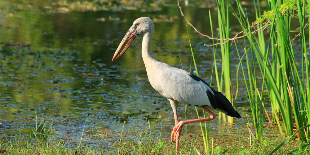 |
Lunama-Kalametiya Lagoons Location: 60 8’ 0 N and 800 54’ 0 E to 60 5’ 0 N and 800 59’ 0 E; 677945 N and 488936 E to 672416 N and 498156 E; about 200 km from Colombo, along the south-eastern coast in the Hambantota District, of the Southern Province of Sri Lanka. Area: Lunama (192 ha) and Kalametiya lagoons (606 ha) Altitude: Sea level to 20 m Overview: The Lunama–Kalametiya wetlands are two brackish water lagoon systems harbouring rich biodiversity including a wide variety of habitats and species. This complex is also an important wintering site for a large number of waterfowl. Although 700 ha have been designated as a wildlife sanctuary, the water management of the wetland is entirely agriculture oriented, rather than for biodiversity conservation. Physical features: The underlying Precambrian formations are predominantly sedimentary rocks and quartz. The main mineral resource is shell deposits that extend over a 1.5-3 km wide sub surface band along the coast. The Kalametiya lagoon opens to the sea through a narrow man-made outlet and is connected to Lunama through a shallow, 2 km man-made channel. These two shallow lagoons, with a mean depth of less than 1 m, are fed by the Kachchigal Ara, and are surrounded by fringes of marsh and mangrove vegetation. During the Indian Ocean Tsunami of 2004, the Lunama-Kalametiya sanctuary and adjoining villages were well protected by a broad, mature and stabilised sand dune that runs parallel to the coastline. Lagoon water levels used to be regulated by semi-natural breaching of a sand bar, but since the construction of the artificial sea outlet, there is an almost year round outflow into the sea. As the area is situated in the dry zone of Sri Lanka, it receives an annual rainfall of 1,000 – 1,250 mm. It experiences two distinct dry spells, in February and July – August. The mean air temperature is around 270C. Relative humidity is in the range of 75 – 80% for most part of the year. Ecological features: The inland and near-shore wetland habitats associated with the two lagoons include mangrove, reed beds, salt marsh, coral reef, sand stone reef, seashore vegetation, and seasonal ponds. The lagoons are surrounded by sand dunes, scrublands, grasslands, coconut plantations, home gardens, rice fields and chena lands. The mangroves around the Kalametiya lagoon, which consisted of a mixture of species about two decades ago, has converted into a Sonneratia dominant stand owing to the drainage of irrigation water and sedimentation. Patches of scrublands located around the lagoons are dominated by thorny species such as Flueggea leucopyrus and Dicrostachys cinerea. A total of 209 plant species have been recorded from the above habitat types, which include 12 climbers, 113 herbs, 39 shrubs and 54 tree species. Two hundred and eighty three species of vertebrates were recorded which comprise of 35 fish, 13 amphibians, 43 reptiles, 168 birds and 24 species of mammals. About 75 species of butterflies have also been recorded. Noteworthy fauna: Out of the 283 species of vertebrates, 14 species are endemic (3 fish, 4 reptiles, 5 birds, and 2 mammals) and 17 species are nationally threatened (2 fish, 7 reptiles, 5 birds and 3 mammals). Among the fish species present in the lagoon, Esomus thermoicos, Clarias brachysoma and Puntius singhala are endemic. Aquatic reptiles include Crocodylus palustris, Lissemys punctata and the endemic serpent Xenochrophis asperrimus, while Python molurus inhabits the mangrove areas. Among the birds recorded, 46 are winter migrants. Rare and/or locally declining wetland bird species include Esacus recurvirostris, Vanellus malabaricus, Phalacrocorax carbo, Pelecanus philippensis and Porzana fusca. Three species of globally endangered marine turtles (Chelonia mydas, Lepidochelys olivacea and Dermochelys coriacea) nest on the beaches of the sanctuary. The mammals present in the surrounding mangroves include two endemic species (Macaca sinica and Moschiola meminna) and three rare and locally declining carnivores (Prionailurus viverrinus, P. rubiginosus and Lutra lutra). Noteworthy flora: Endemic plants present around the lagoons include Vernonia zeylanica, Cassine glauca, and Memecylon sylvaticum. The mangrove bordering the Kalametiya lagoon is dominated by Sonneratia caseolaris, while those in Lunama are dominated by Excoecaria agallocha. The frequently inundated areas of the lagoon consist of salt marsh communities, dominated by salt-tolerant species such as Halosarcia indica. The reedbeds adjoining the lagoons are dominated by the exotic Cattail (Typha angustifolia). Land use: Fisheries, shell mining, chena and paddy cultivation and livestock production are the major land use activities. Additionally, the surroundings are used for human settlements. Possible changes in land use: Encroachment of human settlements into the sanctuary area and expansion of the agricultural lands may result in increased use of land area for agriculture and housing. Changes in the hydrology may lead to the decrease of fisheries livelihoods in the lagoon. Already this has resulted in a decline in lagoon fishing by around 60%. Many poor fishermen in Tuduwa DS, have been forced to seek alternative livelihoods in the form of labour, rearing and selling chickens, and mining for shells as lagoon fishing now only makes up about 25% of their income. Furthermore, when the children of these households reach working age they often seek employment in towns and cities, often in factories, rather than entering traditional fishing due to the decreased benefits. Hydrological and biophysical values: Sand dune habitats shielded the wetland from the recent tsunami disaster; however, the tsunami waves were funnelled into the Kalametiya lagoon through the man-made opening to the sea. This site is important for flood control and nutrient retention. Social and cultural values: The lagoons have been important for sustaining livelihoods and providing numerous goods and services for the local community. Although the importance of the lagoons to the livelihood of the local population has declined considerably, many people still rely on them to supplement their income and to meet nutritional needs, if not for their main livelihood activity. Scientific research and monitoring: Several ornithological and turtle surveys have been conducted including a joint survey by the IWRB and the Ceylon Bird Club in 1995. IUCN conducted a biodiversity survey in the latter part of 2002 to determine the current status of biodiversity in and around the lagoon area. Conservation education: Some awareness raising for local communities was carried out by IUCN as part of a GEF funded management project in the area. Several other education activities are being carried out or are being planned as part of the ADB funded CRMP activities being undertaken by the CCD. Recreation and tourism: A visitor centre is currently being established under the CRMP. Ornithologists regularly visit the wetland. Conservation measures taken: Recognizing the importance of the wetland’s biodiversity, this site was declared a Sanctuary under the FFPO in 1984. In 1995, the CEA prepared a site report and a conservation management plan while the Forest Department in collaboration with IUCN prepared a mangrove management plan. IUCN prepared a biodiversity status profile of the site in 2005. Presently, the ADB funded CRMP and GEF funded RUK projects have initiated several activities within the area. The Kalametiya Community Development Foundation has been established to carry out SAM activities under the present CRMP. Conservation measures proposed: Major recommendations proposed by IUCN and the CRMP include the declaration of the wetland as a Ramsar site; expansion of the sanctuary area to include the Ussangoda scrubland, grassland, beach and near-shore marine habitats such as coral reefs, provision of necessary resources for regular monitoring, demarcation of sanctuary boundaries, zoning of the sanctuary; issuing of permits to regularise illegal shell mining, preparation of a catchment development plan, de-siltation of the lagoon, restocking of the lagoon with fingerlings and creating self-employment opportunities. Disturbance and threats: The salinity of the Kalametiya lagoon has decreased due to the unsustainable development activities carried out in the catchment of the Kachchigal Ara. This problem was aggravated with the construction of a canal through the lagoon, which has in turn caused a decrease in the originally well-established commercial fishery to an insignificant low subsistence fishery. Drainage of irrigation water has lowered the salinity of the lagoon water, which in turn has aggravated the spread of invasive alien plants such as Typha angustifolia, Salvinia molesta and Eichhornia crassipes. Other invasives such as Prosopis juliflora and Opuntia dillennii have also become established around the lagoons. Additionally, eutrophication of lagoon water due to increased agrochemicals has led to the spread of aquatic weeds and the occurrence of fresh water microphytes. Silt accumulation has filled up 40% of the Kalametiya lagoon within the last 15 years. Oxygen depletion in the water body is another reason for the depletion of the fishery resources in the lagoon. The December 2004 tsunami destroyed about 5% of the mangrove cover and increased the salinity levels of the lagoon water. Seawater entering the lagoon during inflow stopped when a canal was constructed through the sandbar to keep the lagoon open throughout the year and thereby prevent frequent inundations of paddy lands located at the northern and eastern edges of the lagoon. This has resulted in serious degradation of the ecosystem, leading to severe resource depletion due to, among others, desalination. Deforestation for human settlements, chena cultivation, and shell mining are other threats to the sanctuary. Funnelling of seawater from the lagoon outlet and artificial canal during the tsunami damaged approximately 10% of the Sonneratia dominant mangrove tree line bordering the lagoon. Need urgent actions to mitigate existing threats. Land tenure: Lagoons are owned by the state, but private lands can also be found within the sanctuary. Management authority and jurisdication: DWC References: CCD (2006c); CEA/ARCADIS Euroconsult (1995e); CEA/ARCADIS Euroconsult (1999); Clemett et al. (2004); Ekanayake et al. (2005); IUCN (2003c) |
| Maps |