 |
Home About Directory Conservation |
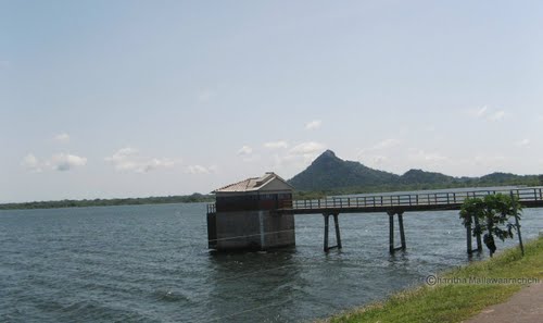 |
Lunugamvehera Reservoir Location: 60 27’ 0 N and 810 9’ 0 E to 60 19’ 0 N and 810 15’ 0 E; 712951 N and 516586 E to 698216 N and 527651 E; about 260 km from Colombo in the Moneragala District of the Uva Province and Hambantota District of the Southern Province. Area: 7,438 ha at full supply level Altitude: Approximately 91m Overview: Lunugamvehera is a multi-purpose reservoir, which was constructed in 1987 by damming the Kirindi Oya under the Kirindi Oya Irrigation and Settlement Project (KOISP). The 198 MCM capacity water body provides irrigation facilities to 5,400 ha of lands serviced by the old Ellegala systems, in the southeastern dry zone of Sri Lanka. Five downstream reservoirs (Debera Wewa, Tissa Wewa, Yoda Wewa, Pannegamuwa and Wirawila reservoir) receive about 30 percent of their inflow from this reservoir. Reservoir associated fisheries play an important role in the livelihoods of the local community. The reservoir and its catchment falls within the Lunugamvehera National Park, which is rich in biodiversity and an important habitat for a large number of water birds as well as elephants. Physical features: The reservoir lies within an agroecological region which is part of the dry zone low country and represents a semi-arid tropical environment. The mean annual rainfall is around 970 mm and of this amount 67% occurs in the Maha season from October to February. The annual average temperature is 300C. Evaporation exceeds precipitation in all months except November and December. As the annual potential evaporation is about twice the rainfall and strong dry westerly winds during the June-September period bring in cyclic atmospheric salts, there is potential for significant accretion of salts in the region. Ecological features: Within the reservoir environs, the vegetation includes different stages of forest succession along with scrub/ grassland mosaics. The shifting cultivation has caused degradation of the forest communities to open thorny scrub and grassland communities. The dense forest, which is dry mixed evergreen, is dominated by Dryptes sepiaria, Manilkara hexandra, Schleichera oleosa, Lannea coromandelia etc. The dominant grassland species include Chloris montana, Eragrostis spp., Ischaemum spp., Cynodon dactylon, etc. Teak and Eucalyptus plantations are also found within the National Park. The vertebrate fauna documented from these habitats include 21 fish, 12 amphibians, 33 reptiles, 184 birds and 43 mammals. Noteworthy fauna: The freshwater fish in the reservoir is dominated by the introduced Tilapia (Oreochromis spp.). Among the amphibians, Bufo atukoralei and Rana gracilis are endemic. Aquatic reptiles include a population of Crocodylus palustris. The reservoir is home to several large water birds (i.e. Ardea cinerea, Threskiornis 145 melanocephalus, Anastomus oscitans, Mycteria leucocephala, Pelecanus philippensis), and functions as an important source of water for wildlife in the National Park, including large herds of Elephas maximus. Noteworthy flora: Tree species such as Dryptes sepiaria and Manilkara hexandra found in the dry-mixed evergreen forest bordering the reservoir are important timber species. Land use: The main water usage is for irrigated agriculture, which consists mainly of paddy cultivations. Farmers also grow other field crops such as chilli, onion, groundnut and banana, when there is insufficient water for paddy cultivation. Home gardens with fruit trees and other permanent vegetation (especially in the old settlement areas) can also be observed. Cattle and buffalo rearing is also a prominent activity. Fisheries are common in the shallow areas of the reservoir and mainly when the reservoir water level is low. Treated reservoir water is also used for domestic consumption. Possible changes in land use: Up to now, municipal and industrial uses have not been major competitors for water use as the area is quite far from the major urban centers. However, there are plans to build an oil refinery on the coast, which would require a large amount of water from the Kirindi Oya irrigation scheme. This may change the agricultural activities from paddy cultivation to other field crops, with less demand for water. Hydrological and biophysical values: The reservoir stores and releases water to irrigate 4,200 ha of land under the old Ellagala system and 850 ha of land under the Bandagiriya irrigation system. The drainage is important to maintain the water levels of the five tanks in the downstream area and the wetland characteristics of Bundala National Park Social and cultural values: Information not available Scientific research and monitoring: Information not available Conservation education: The Veheragala irrigation project conducts programmes on environmental protection on a regular basis. Recreation and tourism: Despite the presence of significant elephant and water bird populations, this park does not attract many tourists due to the presence of more popular parks such as Yala in the vicinity. Additionally, the park does not have visitor facilities at present. However, some people do come to see the reservoir. Conservation measures taken: An area of 23,498 ha was declared as a National Park in 1995, including the reservoir and its catchment, with the objective of protecting both the wildlife and the reservoir. The park serves as a link between the Yala Protected area complex and Udawalawe National Park and facilitates the ranging of elephants to and from areas such as Haldummula and Koslanda. Additionally, in 2005 the reservoir was declared a FMA under FARA. Conservation measures proposed: Information not available Disturbance and threats: Salinity intrusion and conflicts between farmers and herdsmen over limited land due to increasing crop damage by elephants are cited as the main threats. Timber felling and poaching also occurs to an extent. Spread of invasive alien plant species such as Lantana camara is a growing concern. Land tenure: State owned Management authority and jurisdication: Reservoir: Irrigation Department Fisheries activities within the area: DFAR Surrounding environs within the national park: DWC References: Bakker M (2000); DWC (2004); Matsuno et al. (2000); Renwik (2001) |
| Maps |