 |
Home About Directory Conservation |
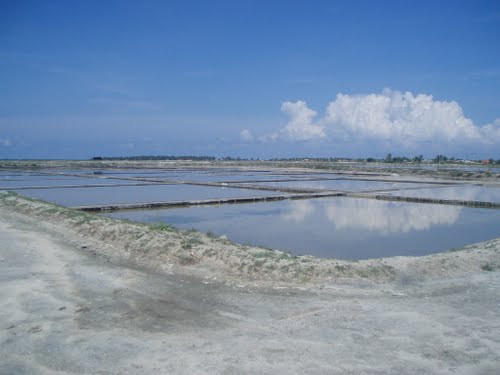 |
Maha and Karagan Lewaya Location: 60 10’ 0 N and 810 7’ 0 E to 60 7’ 0 N and 810 50’ 0 E; 681630 N and 512907 E to 676173 N and 592208 E; near Hambantota town in the Hambantota District, of the Southern Province. Area: 1,160 ha (Maha Lewaya = 260 ha; Karagan Lewaya = 900 ha) Altitude: From 60 m in the northeast (catchment) to 1.5 m below sea level at the bottom of the lagoon. Overview: Maha Lewaya and Karagan Lewaya are naturally formed hyper-saline shallow lagoons, which serve as important refuges for migratory water birds. Karagan Lewaya is separated from the sea by the main Colombo-Hambantota road and by sand dunes, with the only connection to the sea being man-made flood control channels. The water levels of the lagoon fluctuate depending on rainfall and the water received from the cascading tank systems in its catchment area. Maha Lewaya has been developed for salt production. This area is also very important as a corridor for elephant populations that generally move between Bundala, Lunugamvehera and Udawalawe National Parks and Madunagala forest reserve. Physical features: The lagoon is about 3.5 km long and 1-2 km wide. The maximum water area in the lagoon is about 3.2 km2, but is subject to high seasonal variations. In the rainy season floods can occur, while in the dry season the lagoon can dry up completely. Surface inflow to the lagoon comes from two sources: irrigated water released from two downstream reservoirs of Karagan Oya tank cascade system, and direct runoff from the catchment. The Karagan Lewaya was created by the deposition of sediments between the eroded inland peneplain and a barrier of coastal rock outcrops, a process that likely started in the Miocene. The narrow outlet to the sea became permanently blocked in the early 1970s. The two wetlands are located in one of the driest regions of the country and experience mean annual precipitation of 1,035 mm. The main wet season is from October to December (Northeast monsoon). Average daily temperatures range from 260C in December to 280C in May. Wind speed is generally high (4-6 m/sec) resulting in high and constant evaporation rates throughout the year Ecological features: A sand dune of approximately 15 m height and 100 to 200 m width is situated in the western part of the Karagan Lewaya. Two types of vegetation are distinguishable: predominantly thorn scrub forests of the catchment and salt-tolerant vegetation of the lagoon (exclusively phytoplankton). Being a shallow wetland surrounded by mudflats, it serves as an excellent habitat for wading birds, particularly migratory birds. Karagan Lewaya acts as an alternative feeding ground for the migratory birds that come to the wetlands within Bundala National Park every year. Noteworthy fauna: Many species of resident and migratory water birds use these two shallow lagoons as feeding sites. These include cormorants (Phalacrocorax niger, P. fuscicollis), large water birds (Ardea cinerea, Threskiornis melanocephalus, Anastomus oscitans, Pelecanus philippensis), medium sized waders (Tringa spp.) and small waders (Charadrius spp.). Flocks of the Greater Flamingo (Phoenicopterus ruber) also visit these wetlands occasionally. Noteworthy flora: The phytoplankton in both lagoons is dominated by blue-green algae such as Microcystis, Nostoc and Oscillatoria Land use: Shell mining is practised on a limited scale in times of low water levels, while salt extraction is carried out at Maha Lewaya. Shifting cultivation, cattle grazing and paddy cultivation are also carried out. Possible changes in land use: Although at present there is no connection with the lagoon and the Uda Walawe irrigation scheme (UWIS), the lagoon is likely to receive high quantities of drainage flow containing agro-chemicals from the proposed extension of the UWIS. This in turn can reduce the salinity levels of the wetland and adversely affect the present ecological status of the lagoon. This may change the lagoon characteristics from being seasonally hyper-saline to a freshwater wetland. Additionally, further development of saltpans for salt production is also possible and can threaten the status of the wetland. The Karagan lagoon has also been identified for the development of a port in the Hambantota District, which could completely alter the lagoon. Hydrological and biophysical values: Flood control (since 1970, the lagoon has had no connection to the sea, with the exception of temporarily built channels through the sandbar for the drainage of excess water). The wetland also acts as a nutrient trap for irrigated water. Social and cultural values: Salt production at Maha Lewaya provides employment for some of the local people and surrounding areas have been traditionally used for free range cattle. Scientific research and monitoring: IWMI has undertaken scientific studies on the impacts of irrigation on the hydrology of the lagoon. The CBC regularly conducts ornithological surveys in this area. Conservation education: Conservation education is carried out in nearby Bundala National Park. Recreation and tourism: This is a popular site with bird-watchers that come to observe the migratory birds, particularly the flamingos during their migratory season. Conservation measures taken: A wetland site report and conservation management plan was prepared in 1994 by the CEA under the Wetland Conservation Project. Although Karagan lagoon was declared as a sanctuary, it was degazetted in 2004. Conservation measures proposed: A number of conservation measures were recommended in the management plan prepared by the CEA in 1994. To date, many of the recommendations have not been implemented and it is therefore necessary to initiate management activities prior to further degradation of the wetland. Disturbance and threats: Degradation of the forests in the catchment area (shifting cultivation, fuel food collection, cattle grazing etc.) is a major threat while excessive shell mining and salt extraction is also problematic. The spread of Prosopis juliflora and Opuntia dillennii around the tidal flats in Karagan lagoon has resulted in the loss of habitats for wading birds. Poaching is also extensive in this area. The current threats in the Karagan lagoon would be further aggravated by the proposed port development project. Need urgent actions to mitigate existing threats. Land tenure: Maha lewaya is state land that has been leased to the National Salt Corporation. Karagan lewaya is state owned. Surrounding areas are partly state owned and partly privately owned. Management authority and jurisdication: Maha Lewaya is under the jurisdiction of the National Salt Corporation while other state owned lands are under the authority of the local government and Divisional Secretariat. References: CEA/ARCADIS Euroconsult (1999); IUCN (2003b); Stanzel et al. (2002) |
| Maps |