 |
Home About Directory Conservation |
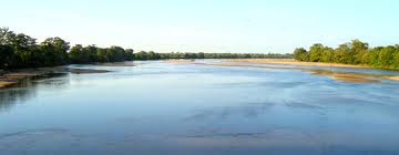 |
Mahaweli Flood Plains National Park Location: 80 21’ 30 N and 800 58’ 0 E to 70 54’ 0 N and 810 15’ 0 E; 922991 N and 496330 E to 873251 N and 527557 E; along the Mahaweli River from its mouth near Trincomalee to Polonnaruwa, in the Trincomalee District and Polonnaruwa District, of the Eastern and North-central Provinces respectively. Area: 50,000 ha Altitude: Sea level to 50 m Overview: The Mahaweli Ganga floodplain is an extensive system of wetlands composed of river channels, riverine marshes, villus, mangroves, lagoons, and tidal creeks associated with the Mahaweli Ganga, Sri Lanka’s longest river. The presence of elephants, rich plant diversity and a large number of aquatic birds including 75 migratory species led to the area being accorded protected status through three National Parks. The flood plains also serve as a migratory corridor between the dry and wet season feeding grounds of a large elephant population. Physical features: The alluvial plain associated with the Mahaweli Ganga begins a few kilometres upstream and the deltaic plain commences with the first distributary, the Kandakadu Aru, with the combined flow entering the sea near Verugal, on the east coast. Around 38 villus have been recorded from the floodplains. Most of them have direct or indirect connections with the river or its tributaries with water flowing into the villus when the river water is high, and the reverse taking place when the water level falls in the river. The area belongs to the low country dry zone and the climate is largely influenced by the northeast monsoon from October to February, which is followed by a dry season lasting from May to September. Average temperature is around 270C, and annual rainfall is around 1,650 mm, with relative humidity varying from 60 - 90% depending on the rainfall patterns. The area is subjected to strong seasonal windy periods. Ecological features: The floodplains of the Mahaweli River are composed of various ecological zones consisting of river channels, riverine marshes, villus, seasonally flooded grasslands and swamp forests. The flood plain in general and the associated villus in particular, have a high diversity of both microscopic and larger plant forms. Two hundred and thirty one plant species were recorded at Handapan and Bendiya villus and swamp forests, which is the largest villu (796 ha) within the Mahaweli Ganga floodplain. The distribution of the larger vegetation in the villus tends to show a characteristic pattern closely related to the hydro-period and the depth of flooding. The aquatic vegetation consists of floating plants (Salvinia molesta, Trapa bispinosa, Pistia stratiotes and Azolla pinnata), submerged plants, grasses and emergent plants (Aponogeton crispus, A. natans and Nymphoides spp.). On the margins of villus, where wet conditions are brief and the depth of flooding is slight, creeping grasses such as Cynodon dactylon are common. The mangroves of the Mahaweli floodplain area are less diverse than those in other parts of the country and the major species recorded are Rhizophora mucronata, Avicennia marina, Acanthus ilicifolius, Lumnitzera racemosa, Aegiceras corniculatum and Scyphiphora hydrophyllacea. Sonneratia apetala exists in small numbers near the mouth of the Mahaweli River. Mangrove associates such as Acrostichum aureum and Hibiscus tiliaceus occur along the inner margins of the mangroves within the transition zone of the riverine forest. Halophytes such as Achrocnemum indicum and Suaeda monoica have been recorded on the fringes of infrequently flooded hypersaline flats. Around 75 migratory bird species spend the winter months in the marshes of the floodplain. Noteworthy fauna: The freshwater fish are dominated by exotic forms (i.e. Oreochromis spp., Osphronemus gourami), while endemics such as Esomus thermoicos, Garra ceylonensis and Schistura notostigma have also been recorded. Common aquatic reptiles include Melanochelys trijuga, Lissemys punctata, Crocodylus palustris, and Varanus salvator. A variety of water birds inhabit the floodplains, including rare ones such as Leptoptilus javanicus. Among the mammals, large herds of Elephas maximus visit the flood plains to feed on the lush vegetation, while other mammals such as Lutra lutra, Prionailurus viverrinus, Moschiola meminna, Cervus unicolor and Panthera pardus have also been recorded in the floodplains. Noteworthy flora: The villus in the floodplain are surrounded by tall dense dry zone forest dominated by Manilkara hexandra, Chloroxylon sweitenia, and Terminalia arjuna species. Prominent grass species include Panicum repens, Hygroryza aristata and Crachiaria mutica. Threatened aquatic plants in the floodplains include Aponogeton jacobsenii and A. natans. Land use: The wetland and its surroundings are mainly used for paddy cultivation, clay mining for brick making, livestock breeding and grazing, cane harvesting, and vegetable and tobacco cultivation. Extensive sand mining also occurs in the Mahaweli Ganga. Possible changes in land use: Proposals for increased water diversion and impoundment schemes for irrigation and hydropower within the upstream areas will result in less water flow to the flood plains, which in turn will affect their hydrological, ecological and resource use patterns. Hydrological and biophysical values: The flood plains are important for flood detention during the wet season. This nutrient rich highly productive environment also provides a habitat for a large number of plants and animals. The flood plain also acts as a sediment and nutrient trap and reduces the input of sediments and nutrients into near-shore marine waters at the river mouth. Social and cultural values: The areas adjacent to the floodplains have largely been developed by the MASL under the Accelerated Mahaweli Development Programme (Mahaweli systems B and C). The vast majority of the families are settled in high grounds, which are protected from the seasonal floodings and are mainly occupied in farming. A number of ancient irrigation networks are present in the area rendering this site culturally significant. Scientific research and monitoring: The Water Resources Board has carried out investigations for tapping groundwater in the lower reaches of the flood plains and deltaic areas. Conservation education: A visitor information centre is located within the Wasgamuwa National Park. Recreation and tourism: Areas within Somawathiya National Park and Flood Plains National Park are currently not open to visitors. However, Wasgamuwa National Park is popular among tourists for its large elephant population. Conservation measures taken: Much of the flood plains are included within the Flood Plain National Park, declared in 1984 covering an area of 17,350 ha of the upper flood plain, and the Somawathiya National Park, declared in 1986 and covering an area of 33,765 ha of upper deltaic plain. These two national parks along with Wasgamuwa National Park (33,765 ha), to the southwest and the Tirikonamadu Nature Reserve (25,032 ha) to the northeast, form a contiguous system of protected areas. Around 30 villus are included within these protected areas which provide an important habitat for migratory elephants. The MASL has constructed an electric fence to minimize human-elephant conflict. In 1995 the CEA developed a wetland site report and conservation management plan for the Handapan and Bendiya Villus. Conservation measures proposed: Expansion of the protected area to include the lower deltaic plain and extensive mangroves at the river mouth and linking all these National Parks together to form a single protected area for the elephants have been proposed. Disturbance and threats: Due to further diversion and impoundments in the upstream areas of the Mahaweli Ganga, the water flow has decreased and one third of the villus are already drying up. This has also facilitated the spread of invasive alien plants such as Eichhornia crassipes, Xanthium indicum and Salvinia molesta, which has affected native grasses and other aquatic plants, resulting in the loss of food plants for native herbivores. Un-authorized tobacco cultivation along the riverbanks, the establishment of brick kilns have degraded natural habitats. Many areas of the floodplains have also been encroached upon by local communities. The abandoned clay pits weaken the riverbank and contribute to the threat of malaria by providing breeding grounds for mosquitoes. Need urgent actions to mitigate existing threats. Land tenure: The protected areas and the Mahaweli area are state owned while the human settlements are privately owned. Management authority and jurisdication: The protected areas are under the jurisdiction of the DWC while the remaining areas under the Mahaweli Development Programme are under the management of the MASL. References: CEA/ARCADIS Euroconsult (1995b); Ekanayake and Ranawana (2001); IUCN (1990); Jayawardena (2005); Kotagama (1989) |
| Maps |