 |
Home About Directory Conservation |
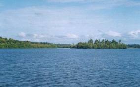 |
Mundel Lake Location: 70 53’ 0 N and 790 45’ 0 E to 70 45’ 0 N and 790 51’ 0 E; 871606 N and 362202 E to 856832 N and 373187 E; 20 km south of Puttalam, in the Puttalam District, of the North-western Province. Area: 3,100 ha. It is approximately 12 km long and 1.3 km wide. Altitude: Sea level Overview: The Mundel ‘Lake’ is actually a shallow brackish water lagoon fringed by mud flats, salt marshes and remnants of mangrove stands which is connected with the Puttalam estuary at the northern end through the Dutch canal. The lagoon is completely cut off from the sea by a narrow sandbar at Udappuwa and the high salinity level of the wetland is maintained due to high evaporation and low rainfall in the area. Aquaculture farms are the most conspicuous developments around the lake while a small-scale subsistence fishery can also be found. The wetland is an important feeding ground for migratory birds. The Mundel Lake and its environs are disturbed as a result of injudicious utilization of resources beyond sustainable limits. Physical features: The area falls within the dry zone of Sri Lanka and therefore experiences two rainy and two dry periods per year. The first rainy season extends from April-June and while the second period occurs between October and November: the transition periods between the prevailing Southwest monsoon (June-October) and the Northeast monsoon (December-February). Average annual rainfall is 1,000-1,500 mm while, monthly rainfall is around 120 mm and the temperature is uniform at around 30.4 –33.60C. The lagoon is very shallow with an average depth of 0.75 m. Salinity is variable between 3ppt and 65 ppt depending on evaporation rates and rainfall. There is some indication that the lagoon in this location used to be larger, however, the current extent of the lagoon has been reduced due to the beach extending inwards to the lagoon. Ecological features: The lagoon and its environs consist of a straight coastline with wide beaches, berms and sand dunes. Old raised dune ridges, mud flats, salt marshes and degraded mangroves border the eastern margin of the wetland. The sand dunes from Deduru Oya mouth northwards consist of a series of medium sized dunes 10-15 m in height, which are active and migratory. Close to the coast, the dunes are covered by creeping vegetation such as Spinifex littoreus and Ipomoea pescaprae. According to 1992 estimates, around 262.04 ha of mangroves are present in the Mundel lagoon, but it has diminished due to accelerated growth of aquaculture farming. A survey in 1987 by NARA recorded nine mangrove species, four mangrove associated species and five salt marsh species. Mangrove associates and adjacent mudflats are highly rich in invertebrates and fishes, and are important for water birds. Around 30 species of finfish have been recorded from the lake. The surrounding salt marshes and tidal waterways are subjected to daily tidal fluctuations Noteworthy fauna: Six finfish species dominate the catches (Nematolosa nasus 42%, Arius sp. 30%, Jobnius carouna 7%, Lates calcarifer 4%, Terapon sp. 3.7%, and Mugil sp. 3.3%). The dominant birds include cormorants (Phalacrocorax niger, P. fuscicollis) and egrets (Mesophoyx intermedia, Egretta garzetta), while migratory water birds include waterfowl such as Anas querquedula and waders such as Tringa stagnatilis and T. nebularia. The threatened mammal Lutra lutra has also been recorded from the site. Noteworthy flora: The common mangrove species include Avicennia officinalis, Lumnitzera racemosa, Excoecaria agallocha and Clerodendrone inerme. The salt marsh vegetation includes Sueda maritima and Salichornia brachiata. Land use: The wetland is mainly used for fisheries and prawn farming. A 1992 survey estimated the land use area by the aquaculture industry to be approximately 350 ha. Agriculture, animal husbandry and livestock farming is common in the surrounding areas. Coconut is the main crop of the area with around 15–20% of families earning extra income from the preparation of cadjans from coconut leaves. These families use the lagoon for retting the leaves Possible changes in land use: Mangrove restoration activities initiated by local CBOs and NGOs in degraded sites could lead to the recovery of mangrove vegetation. Natural regeneration of mangrove is also evident around some of the abandoned shrimp ponds Hydrological and biophysical values: During heavy rains, flood control in the area happens through the physical breaching of the Udappuwa sand bar. Water circulation between the Puttalam estuary and Mundel lagoon is determined by rainfall. During rainy seasons, the water level in the Mundel lagoon is higher and therefore water flows towards the Puttalam estuary. During the drier months, water flows from the estuary to the lagoon. The water of this lagoon is used for aquaculture purposes in the nearby shrimp farms. Social and cultural values: 40-50% of the families in the surrounding villages are engaged in lagoon fisheries, which is the main source of income for the local communities. While some of the fishermen sell their catch fresh to the whole-sellers on the beach, others prepare dry fish for sale. Livestock farming is done on a small-scale near the lagoon and only around 3-5 % of the families rear chicken, cattle and pigs. Scientific research and monitoring: NARA has conducted several studies on the effects of shrimp culture on the lagoon. Conservation education: Several CBOs, NGOs and government institutions (i.e. NARA) have carried out awareness raising activities related to the Mundel lagoon and its threats. Recreation and tourism: Tourism used to be centred around the large number of migratory birds that used to visit the area. However, destruction of the mangrove stands has led to a decrease in the migratory bird populations visiting the area. Conservation measures taken: A small fishery organisation located in the area has started to restore the mangrove ecosystem. Conservation measures proposed: The wetland site report and conservation management plan produced by the CEA recommend actions for the conservation of this site. Disturbance and threats: Aquaculture and fisheries development and the lack of enforcement of rules and regulations are the major threats to the area. Vast areas of mangrove have been cleared for the establishment of aquaculture ponds. The use of dragnets has damaged the benthic organisms and sea grass beds. The application of nonsustainable fishing techniques such as fish kraals across the Dutch Canal not only obstructs water flow but also impedes recruitment of fish and shrimp from the sea. Construction of shrimp farms in lagoon mud flats as well as water retention areas has increased the incidence of floods in the area. From 1990-2000 almost 90% of the fringing vegetation of the lagoon and its environs had been cleared to construct aquaculture ponds. Release of untreated water from shrimp farms reduces the salinity levels and degrades the water quality of the lagoon, which in turn reduces its fishery potential. Increased sedimentation of the lagoon has affected the rainwater retention capacity of the wetland. Reduction of environmentally sensitive areas has caused a reduction in biodiversity. Migratory bird populations visiting the area have reduced by 48% between 1998-99 compared to 1992-93 due to the large-scale destruction of mangrove stands. The fish diversity has reduced from 19 species caught in 1991 to 14 species in 2000. Need urgent actions to mitigate existing threats. Land tenure: The lagoon and the corridor are state-owned while some of the surrounding lands are privately owned. Management authority and jurisdication: Settlement areas come under the purview of the GA. References: BirdLife International (2005); CEA/ARCADIS Euroconsult (1994e); Corea and Jayasinghe (2002); Dayaratne et al. (1997); Katupotha (2002). |
| Maps |