 |
Home About Directory Conservation |
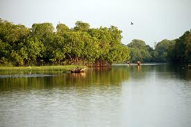 |
Pottuvil Lagoon Location: 60 57’ 0 N and 810 46’ 15 E to 60 50’ 0 N and 810 51’ 30 E; 768290 N and 584691 E to 755407 N and 593920 E; 3km north of Arugam Bay in the Ampara District, of the Eastern Province. Area: Information not available Altitude: Sea level Overview: Pottuvil lagoon is a brackish water coastal lagoon surrounded by sand dunes, salt marshes, mangroves, coconut plantations and home gardens. The lagoon is connected to the sea on its eastern side via a narrow channel. Freshwater input is from rainfall and several small streams, and the lagoon is seasonally tidal. Physical features: The lagoon is located in the low country dry zone, where the mean annual temperature is 27.40C and the annual rainfall varies between 700 – 1,700 mm. Most of the rain is received during the northeast monsoon between October-February, while the driest period is between May and September. Maximum depth of the lagoon is 2-3 m, while salinity varies seasonally and can be over 30 ppt at times. Winds are generally moderate, ranging from 7–15 km per hour with stronger winds during the evening. Ecological features: The area surrounding the lagoon is primarily composed of mangroves while a smaller percentage of land area is covered with coconut plantations, homesteads, sand dunes and grasslands. The lagoon is an important habitat for water birds including migratory species. Noteworthy fauna: Two species of nationally threatened and globally vulnerable birds (Leptoptilos javanicus and Pelecanus philippensis) have been recorded from the lagoon. Noteworthy flora: Mangrove species such as Excoecaria agallocha, Rhizophora mucronata, Lumnitzera racemosa, Acanthus ilicifolius, Phoenix pusilla, Aegiceras corniculata, Bauhinia racemosa, Avicennia marina and Bruguiera spp. are found around the lagoon. Land use: The main use of the lagoon is for fisheries. Paddy cultivation is the major activity in areas surrounding the lagoon and the Ampara District is the largest rice-producing region of Sri Lanka. Additionally, there are many human settlements and coconut plantations in the vicinity. Tourism infrastructure is also found in nearby areas, and the lagoon is increasingly being used for eco-tourism. Possible changes in land use: Increased encroachment of the lagoon for housing and tourism infrastructure due to the increasing population and growing popularity of the area among tourists. Hydrological and biophysical values: The lagoon is important for flood control, and the adjoining sand dunes are important in coastal protection from storm surges and other natural disasters such as tsunamis. Social and cultural values: The lagoon sustains a small but important subsistence fishery and many people have been traditionally engaged in fisheries. More recently, ecotourism has become popular and provides income to locals. A 2000 year old temple, the Muhudhu Maha Viharaya is located nearby. Scientific research and monitoring: Information not available Conservation education: Information not available Recreation and tourism: The lagoon has recently become popular among tourists, and the Hidayapuram Fishermen’s Cooperative Society runs a community-based ecotourism venture called the Pottuvil Lagoon Ecotour. Conservation measures taken: Attempts have been made to encourage community-based conservation through the Fisherman’s Cooperative Societies. During the 2003-2004 period a mangrove nursery was established, managed and funded by the local Fisherman’s Cooperative Societies in order to improve mangrove habitats around the lagoon, while local fishermen have also stopped the illegal shooting of birds in the lagoon. The fishery is also managed by the Pottuvil and Arugam Bay Fishermen’s Association. Conservation measures proposed: Information not available Disturbance and threats: Pollution, land-filling and cattle grazing are the most prevalent threats causing habitat degradation and modification. Grazing by cattle in particular, causes damage to replanted mangrove seedlings. Additionally, the lagoon area was affected by the tsunami, which resulted in damage to mangroves and deposition of debris in the lagoon. Another prominent threat is the high rate of siltation, which may have increased after the tsunami. The invasive species Pistia stratiotes is found extensively in the area. Land tenure: The lagoon is state-owned while the surroundings are partly state owned and partly privately owned. Management authority and jurisdication: This site is within the jurisdiction of the Pottuvil GN. References: IUCN (2005a); Kotagama (1989); Mallawatantri (2005) |
| Maps |