 |
Home About Directory Conservation |
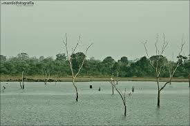 |
Udawalawe Reservoir Location: 60 32’ 0 N and 800 46’ 0 E to 60 20’ 0 N and 800 56’ 0 E; 722167 N and 474203 E to 700053 N and 492627 E; about 200 km south east of Colombo within the Udawalawe National Park, spanning the Ratnapura and Monaragala Districts, of the Sabaragamuwa and Uva Provinces. Area: 3,400 ha at full supply level Altitude: Approximately 100 m Overview: Uda Walawe Reservoir is a large multipurpose storage tank constructed in the mid 1960s by damming the Walawe Ganga as part of a plan to develop the irrigation capacity of land in the dry zone of southern Sri Lanka. Apart from irrigating adjoining agricultural lands, it generates about 6GWh of hydroelectricity per year. The reservoir is situated within the Udawalawe National Park, and therefore plays a significant role in maintaining the rich biodiversity of the area, and is particularly important for water birds and elephants. It is a very popular tourist destination and is the third most visited park in the country. Physical features: The reservoir is located on the boundary of the wet and dry zones of Sri Lanka and receives around 1500 mm of rainfall annually. The highest rainfall is during October to January and again from March to May. The relative humidity varies between 70 and 82%, while the annual average temperature ranges from 270-280C. The major soil type in the area is the well-drained reddish brown earth (47%) and the poorly drained low humic grey soils in the valley bottoms (34%). Alluvial soils are found in some locations along the rivers and streams. In the Udawalawe reservoir, the average annual amplitude in water level is 8 m, which changes the aquatic area from 34.4 to 14 km2 and the reservoir capacity from 268.6 to 80 MCM. These fluctuations produce large drawdown areas with terrestrial plant growth, which form part of the energy and carbon sources of the aquatic ecosystem after inundation, and cause dramatic changes in the internal exchange process between the bottom sediments and the water column. Ecological features: The major habitat types surrounding the reservoir include the immediate marshy fringes, the Walawe river and major tributaries within the Park, and the forest and grassland. A characteristic feature of the reservoir is the dead tree trunks standing in the water, which are remnants of the forest that existed prior to the construction of the reservoir. A study conducted in 1986 revealed the occurrence of green algae (Pediastrum sp. and Scenedesmus sp.) and blue green algae (Microsystis spp.) in the reservoir. Of the zooplankton recorded, the most abundant taxonomic group was the rotifers. The Park includes forested land in various stages of succession, along with extensive grasslands. The forested land was largely cleared in the 1960s and the grassland communities are the result of chena cultivation The reservoir is surrounded by open scrub jungle in the north and east, and by cultivation areas in the west and south (those in the west are illegal as they are within the boundaries of the National Park). In the south, below the reservoir bund, there are sugar cane plantations and paddy fields. In the south-eastern corner there are teak plantations which were established under a tree plantation programme of the Forest Department before the park was gazetted. 94 species of plants have been recorded from the park, while 21 species of fish, 12 species of amphibians, 33 species of reptiles, 184 species of birds (including 33 migrants) and 43 species of mammals have been recorded from the environs within and surrounding the reservoir. Among the invertebrates, 135 species of butterflies have been recorded. Noteworthy fauna: One endemic fish species (Garra ceylonensis) is recorded from the Walawe River within the park boundary. The introduced fish species (i.e. Oreochromis spp., Osphronemus goramy, Catla catla, Labeo rohita) that are found within the reservoir are important food fish species. An array of waterbirds inhabits the reservoir, including large flocks of cormorants (Phalacrocorax spp.), Pelecanus philippensis, Anastomus oscitans, Mycteria leucocephala, Threskiornis melanocephalus and Platalea leucorodia. The reservoir plays a significant role in sustaining a large herd of elephants in the Park. Noteworthy flora: Four endemic plant species (Hopea cordifolia, Memecylon petiolatum, Erythroxylon zeylanicum and Jasminum angustifolium) have been recorded from the park. Among them the dry zone Dipterocarp - Hopea cordifolia is a noteworthy plant species found along the river. The dominant grass species Panicum maximum and Imperata cylindrica are important food sources for herbivorous species such as the elephant. Land use: Fisheries within the reservoir occur on a small scale, mainly at subsistence levels. The surrounding land mainly falls with the National Park and therefore human impact is minimal, although illegal settlements are found in the vicinity. The downstream area is mainly used for paddy, banana and sugarcane cultivation, chena cultivation, human settlements and livestock grazing. The park is used for tourism and the Udawalawe - Tanamalwila road runs over the dam. Possible changes in land use: There are several planned development projects for the area. The Irrigation Department has proposed to divert the water of the Mau Ara to the Malala Oya in order to irrigate more land. For this, another dam will be built upstream of the existing Udawalawe reservoir, which might have a negative impact on the water flow to the reservoir. The management plan developed under the ADB/GEF project suggests activities such as boating and rafting within the reservoir environment to attract tourists. Hydrological and biophysical values: Udawalawe reservoir sits within the Walawe River basin with a total catchment area of 2,442 km2 and has an estimated average discharge volume of 2,165 million m3 into the sea. The reservoir has a live storage capacity of 240 MCM and a power generating capacity of 6 MW. There are two main canals, the right bank main canal, which is 42 km long and the left bank main canal, which is 31 km in length. Presently, the total irrigated area is as high as 17,400 ha. During the dry season when water levels are low, elephants congregate in the draw-down areas of the reservoir. Social and cultural values: Modern water resource development in the Udawalawe basin is superimposed over a rich history of water management and irrigation dating back to historical times. According to a survey carried out by IWMI in 2003, over 1,600 families are involved in inland fishing activities, and of this, two-thirds fish as a means to supplement family nutritional needs or incomes. Around 38,000 households are found in the Udawalawe area of which half are farming households. The type of farming in the study area varies between irrigated, rain-fed and chena. The DWC employs some of the villagers on a daily basis for the Lantana camara eradication project. Scientific research and monitoring: In 1975, an aquaculture development centre was established near the reservoir by the NAQDA which conducts regular research on fish breeding. A study on small mammals of the Park has been undertaken, while detailed information on the avifauna is regularly gathered by several groups. The CBC has been conducting an annual mid-winter waterfowl census since 1987. In the Framework of the Forest Department/ IUCN Conservation Review Project, an inventory was made of the fauna and flora of the area, which was later strengthened by the GEF funded project carried out by the DWC. In 1993, an elephant census was carried out within the park by the DWC. The field station for reservoir fishery development carried out considerable research on fisheries prior to its closure in 1989 when the Government decided to terminate support to inland fisheries. IWMI has also conducted several studies on water resource development of the reservoir. At present, research on the re-introduction of orphaned elephants is being conducted in conjunction with the Born Free Foundation. Conservation education: Information not available Recreation and tourism: Udawalawe National Park is the third most visited wildlife park of the country, and is especially popular for its large elephant population. Three park bungalows have been constructed by the DWC, while there are also bungalows belonging to the Sugar Corporation, Fisheries Corporation, MASL, and the WNPS in the vicinity. Between 1994 and 2001, 452,000 persons, of which 20% were foreigners visited the park. The average revenue for the period between 1998 and 2001 period was US$ 280,000 Conservation measures taken: The reservoir and a large part of its catchment are protected within the Udawalawe National Park, which was declared under the FFPO in 1972. The main reasons for establishing the 30,821 ha park were to protect the immediate upstream catchments and to provide a refuge to wildlife that was displaced by the clearing of land in the lower reaches of the Walawe River. In 1995 the CEA published a wetland site report and conservation management plan for the reservoir. The Udawalawe Reservoir Fisheries Society established under the Fisheries Act is functioning effectively at present. Under the UNDP/GEF development of wildlife conservation and protected area management project, an eco-development plan for the National Park was developed. In 2005, the ADB/GEF funded PAM project lead to the publication of new management and operation plans. The DWC has initiated a project to physically remove the invasive plant Lantana camara from within the National Park. Conservation measures proposed: Under the ADB/GEF funded PAM project activities within the national park including demarcation of the park boundary, fencing off of the elephant corridor to allow secure elephant migration, zoning, buffer zone establishment, improvement of visitor facilities and staff training for tourism are underway. Disturbance and threats: Reduced rainfall, high sedimentation of the reservoir due to poor land-use planning at the upstream areas including activities such as clearing of natural forests and planting of monospecies cultures of Pinus and Eucalyptus, and large scale fish kills upstream of the reservoir attributed to river flow interception without measures for stream flow management have affected water levels and aquatic biodiversity. Encroachment of the park by human settlements, poaching, illegal timber extraction, gem mining, animal grazing (around 30,000 cattle) and chena cultivation are activities that pose a threat to the wetland area and the entire National Park. Alien plant invasions and uncontrolled visitation are also becoming problematic. Invasive plant species such as Lantana camara and Phyllanthus polyphyllus pose a clear threat to the food plants on which elephants depend. Land tenure: The National Park area is state owned and most lands in the irrigation systems are also state owned. Certain limited rights have been granted to settlers on state lands. These include mortgage rights, transfer to family members or heir and temporary or seasonal leasing out rights. Management authority and jurisdication: The National Park is under the jurisdiction of the DWC. Operation of the reservoir is handled by the MASL. The MEC bears responsibility for settling farmers and promoting socio-economic development in the downstream areas. The Ceylon Electricity Board controls the hydro-power generation of the dam. References: ADB (2000); CEA/ARCADIS Euroconsult (1995f); De Silva et al. (2001); DWC (2005b); DWC (2005c); Handawela (2002); Hussain et al. (2002); Molle and Renwick (2005); Schiemer et al. (2001) |
| Maps |