 |
Home About Directory Conservation |
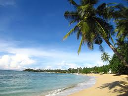 |
Unawatuna Reef Location: 60 3’ 0 N and 800 13’ 30 E to 50 59’ 30 N and 800 16’ 0 E; 668794 N and 413314 E to 661416 N and 418838 E; within Unawatuna Bay, in the Galle District, of the Southern Province. Area: Reef area unknown Altitude: Sea level to a depth of 8m Overview: Unawatuna contains a shallow coral reef as well as numerous rocky reef habitats. The beach is popular for tourism and surrounding reefs are popular for diving and snorkelling. The reef is degraded, mainly due to coral bleaching, while human activities continue to pressurize remaining reef resources. The area has now been selected as a site for SAM by the CCD. Physical features: The reef is located within Unawatuna Bay, less than 50m from the beach and is partially protected by a headland. It does not have a distinguishable reef crest and slope, although a small reef crest and sheltered inner reef area is found at the western end. Coral patches exist throughout the Unawatuna Bay, but most are found towards the western shore of the bay at depths between 1-5m. A group of rocky islets are located at the mouth of the bay. Unawatuna is located in the wet zone and receives an average annual rainfall of over 2,000 mm. The reef is influenced by the southwest monsoon, which results in rough seas and strong winds and currents from May to October. The temperature range in the area is 26.60C to 32.60C while the pH range is 7.83-8.29. Ecological features: The reef was dominated by tabulate Acropora and branching Pocillopora with a live coral cover of nearly 50%, but most corals were killed during the El Niño related coral bleaching event in 1998. Some Acropora and Pocillopora have recovered from bleaching while large stands of Porites are also found around the rocky islets. The fish community is dominated by damselfishes (Pomacentridae) and wrasses (Labridae). Noteworthy fauna: Among the reef fish, Chlorurus rhakoura and Pomacentrus proteus are restricted to Sri Lanka, while Cheilinus undulates is globally endangered. Five species of globally endangered marine turtles (Eretmochelys imbricata, Chelonia mydas, Lepidochelys olivacea, Caretta caretta and Dermochelys coriacea) visit the reef. Noteworthy flora: Marine algae Land use: Tourism is the dominant activity in the area and the coastal area is dominated by hotels, restaurants and shops. Fishing is carried out mostly in offshore waters while collection of ornamental fish is carried out on the fringing reef as well as offshore reefs. Possible changes in land use: Extensive reef degradation due to coral bleaching has seriously affected populations of ornamental fish and has impacted associated livelihoods. Continued degradation of the reef due to human impacts and beach erosion may result in decreased appeal as a tourist destination. Hydrological and biophysical values: The reef provides protection to the shoreline from rough seas and is important for mitigating coastal erosion, which is a major problem at Unawatuna. Social and cultural values: Up to the 1970’s Unawatuna was a community of subsistence fishermen. Since then, the area has been gradually transformed into a tourist resort with a large number of guest houses and restaurants. A third of the population is still dependant on fisheries, although many take up tourism related livelihoods in addition to fishing. The fishermen use traditional (outrigger) and small motorized boats. Collection of spiny lobster and ornamental fish are also popular due to high economic returns. Additionally, there are a number of historically and culturally important sites within the area. Scientific research and monitoring: The reef has been studied and is currently being monitored by NARA. Several studies have been undertaken as part of the SAM process while periodic surveys have been conducted by the Nature Conservation Group. Conservation education: Education and awareness activities are currently being carried out as part of the SAM planning process. Several local NGOs and CBOs are also involved in education and community based conservation initiatives. Recreation and tourism: Unawatuna is one of the most popular tourist areas along the southern coast. Numerous hotels, restaurants and tourist shops are found along the Unawatuna Bay and surrounding area. Several SCUBA diving operators conduct diving and snorkelling excursions to reefs in the area. Conservation measures taken: The reef and surrounding coastal area has been included into the Habaraduwa SAM plan by the CCD to initiate participatory community based management. Conservation measures proposed: The reef has been proposed as a Marine Sanctuary by NARA but has not yet been declared as such. A proposal to install mooring buoys for diving boats has been made by local CBOs and dive operators which will decrease the damage caused to the reefs by anchors. Disturbance and threats: The use of destructive methods for collection of ornamental fish and spiny lobsters, anchoring of boats and reef walking are damaging the reef. Unregulated and poorly planned tourism is a major issue at Unawatuna. Discharge of wastewater and sewage from hotels and houses have degraded the water in the near-shore environment and threaten the survival of the coral reefs. Unauthorized construction and encroachment onto the beach have destroyed natural vegetation and aggravated coastal erosion, as well as led to visual pollution of the area. Recent developments have also prevented turtles from nesting along these beaches. The reef was severely degraded by the 1998 El Niño induced coral bleaching event. The 2004 tsunami also caused physical damage to sections of the reef slope due to the movement of large dead coral blocks and coral rubble. Need urgent actions to mitigate existing threats. Land tenure: State owned Management authority and jurisdication: CCD for areas within the coastal zone and the DFAR for fisheries management References: CCD (2005a); CCD (2006b); NARA/CORDIO/IUCN/GCRMN/SLSAC (2005); Öhman et al. (1998); Rajasuriya (2005); Rajasuriya et al. (1995); Rajasuriya et al. (1998) Weeramundi (1999) |
| Maps |