 |
Home About Directory Conservation |
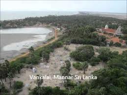 |
Vankalai Triangle Location: 80 59’ 22 N and 790 52’ 5 E to 80 51’ 46 N and 790 59’ 0 E; 993202 N and 375417 E to 978421 N and 388203 E; Coastal area bounded by Vankalai, Puliyantivu island and Tiruketiswaram in the Mannar District, including the causeway between the mainland and the Mannar island. Area: Approximately 1000 ha Altitude: Sea level Overview: The area includes a cluster of coastal and marine wetlands, including shallow lagoons, sea-grass beds, seasonal waterholes and tanks, mangrove and salt marshes. The mosaic of wetland habitats is also located within the Central-South Asian migratory bird flyway making it one of the most important bird habitat areas in Sri Lanka. Physical features: The area forms part of the north-western semi-arid zone of Sri Lanka, receiving a mean annual rainfall around 950 mm, mainly during the northeast monsoon period between October and February. The heaviest rainfall is received from October to December. The average annual temperature is around 270C. Ecological features: The area consists of numerous coastal and marine wetlands, and patches of arid zone dry thorn scrub, arid zone pastures and maritime grasslands, and sand dunes. The vegetation in thorn scrub consists of two distinct strata; a tree layer dominated by Acacia planifrons, Salvadora persica and Tamarindus indicus, and a shrub layer with species such as Azima tetracantha, Cassia auriculata, Dichrostachys cinerea, and Flueggea leucopyros. The open areas consist of arid zone pastures and grasslands, which are dominated by grasses (i.e. Cynadon dactylon) and sedges (i.e. Cyperus rotundus). These open areas are dynamic ecosystems that are transformed into seasonal water bodies during the rainy season. The shallow seasonal water holes contain algal species and submerged vegetation such as Najas marina. The single perennial tank in the area is home to floating plants such as Nymphaea stellata and Nelumbo nucifera. The patches of degraded fringing mangrove in this area are dominated by species adapted to high-saline conditions (i.e. Avicennia marina). The shallow margins of lagoons and seasonal water bodies are covered with patches of salt-marsh vegetation consisting of Halosarcia indica, Salicornia brachiata and Suaeda spp. The sand dunes and sandy sea-shore adjoining the lagoon support sparse Spinifex littoreus and Hydrophylax maritima dominated vegetation. The shallow lagoon has patches of sea-grass beds. The tidal effect in the shallow lagoons results in the exposure of tidal mudflats, consisting of very rich organic matter that supports a high richness of invertebrates, which in turn attracts diversity of water birds. A total of 149 bird species have been recorded from this area, including a large number of migratory species, amounting to more than 20,000 individuals annually. Noteworthy fauna: The site harbours an array of migratory waders and waterfowl. Large populations of Phoenicopterus roseus, Anas penelope, Anas acuta and Limosa limosa have been observed in the site. A notable species in this site is the Indian Spot-billed Duck (Anas poecilorhyncha), of which a breeding population was discovered recently. Until 2003, this species was known as a very rare migrant. Two species of rare migratory waterfowl that visit the site include Anas strepera and Sarkidiornis melanotos. Among the other aquatic animals, two species of reptiles (Melanochelys trijuja and Crocodylus porosus) have been observed from this area. Noteworthy flora: The patches of fringing mangroves in the area consist of Avicennia marina, Aegiceras corniculatum, Excoecaria agallocha, Clerodendrum inerme, Rhizophora mucronata, Lumnitzera racemosa and Pemphis asidula. The patches of sea grass beds scattered in the lagoon consist of Enhalus acoroides, Thalassia hermprichii, Halophila ovata and Halodule uninervis. Land use: Except for a few permanent settlements in the Thiruketiswaram area, the rest of the area is devoid of human settlements. A small Army camp is present in the area. Collection of fuel-wood and livestock grazing is done on a small scale. The civil war has kept off human activity from this area for nearly two decades. Locals in the surrounding areas carry out subsistence fishing in the shallow lagoons. Possible changes in land use: If the security situation improves, it is likely that human use of the wetlands and surrounding areas will increase significantly. The open areas and scrublands could be converted into uniform stands of Prosopis juliflora, due to the spread of this invasive alien species. Hydrological and biophysical values: These wetlands play an important role in nutrient cycling within the southern Palk Bay area and are connected to the extensive coastal and marine ecosystem complex of the Palk Bay and Gulf of Mannar. The wetlands are also important in flood detention during the rainy season. Social and cultural values: This area is sparsely inhabited but is historically significant due to the location of several ancient harbours. It is believed that the first Indian settlers in Sri Lanka arrived in the Mannar area. Scientific research and monitoring: The CBC conducts annual censuses of waterfowl in this area. Conservation education: The CBC has written several articles highlighting the conservation significance of this site. Recreation and tourism: Although the site is a bird watchers paradise, the current civil war has prevented many people from visiting this area. Conservation measures taken: This area used to be subjected to illegal hunting of waterfowl, but the presence of the Army has resulted in a reduction of poaching activities. Conservation measures proposed: The CBC has urged the government of Sri Lanka to propose this area as a Wetland of International Importance (Ramsar site). Disturbance and threats: The spread of two invasive alien plants, Prosopis juliflora and Opuntia dillennii has affected the open areas such as pastures and maritime grasslands. These two species are also found around scrublands, seasonal waterholes and also around salt marshes. Free roaming livestock have facilitated the spread of P. juliflora in this area. Large areas of natural vegetation have also been cleared for security reasons. Land tenure: State owned Management authority and jurisdication: The coastal area falls within the legal jurisdiction of the CCD. References: CBC (2006); Siriwardana (2003); Kithsiri Gunawardena personal communication |
| Maps |