 |
Home About Directory Conservation |
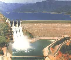 |
Victoria Randenigala Rantambe Reservoirs Location: 70 25’ 0 N and 800 40’ 0 E to 70 5’ 0 N and 810 0’ 0 E; 819824 N and 463216 E to 782961 N and 500000 E; spanning the Mahaweli Ganga between Kandy and Minipe anicut within the Districts of Kandy and Nuwara Eliya in the Central Province, and Badulla District in the Uva Province. Area: Surface area of reservoirs is 4,992 ha (Victoria 2,440 ha; Randenigala 2,419 ha; Rantambe 133.8 ha), while the Sanctuary area is 36,507 ha. Altitude: Information not available Overview: The Victoria, Randenigala, and Rantambe (VRR) reservoirs were constructed during the late 1980’s under the Accelerated Mahaweli Development Programme, to meet the energy needs of the country, and also to provide irrigation water to the dry zone. In order to protect the upper catchment of the Mahaweli Ganga, the surrounding land area of these reservoirs was declared as a sanctuary in 1987. In addition to these major reservoirs, there are many small artificial and natural water bodies located within the sanctuary. Physical features: The VRR sanctuary is located in the intermediate zone of the country, receiving an annual rainfall of 1,500- 1,700 mm. The mean annual temperature is around 26oC. The VRR sanctuary is composed of Precambrian metamorphic rocks classified under two distinct rock types namely Highland and Vijayan. Major rock types found in the area include Charnockitic Gneiss, Quartzite, Marble, Hornblende Biotite Gneiss, Sillimanite Gneiss, Garnet Biotite Gneiss, Magmatites, and Pink Feldspar Granitic Gneiss. Fourteen seasonal and perennial streams flow through the VRR sanctuary, and Uma Oya and Kurundu Oya have become major perennial streams of the area. Several islands are located within the Randenigala reservoir. The Victoria, Randenigala and Rantambe reservoirs have storage capacities of 722 MCM, 860 MCM, and 7 MCM respectively, with power generation capacities of 210 MW, 126 MW, and 49 MW. Dam heights are 122m at Victoria, 94 m at Randenigala, and 41.5 m at Rantambe. Ecological features: Major habitat types include fresh water wetlands (reservoirs, streams, tanks, irrigation canals, marshes, paddy lands), and intermediate zone tropical-semi evergreen forest. Other vegetation types in the VRR Sanctuary include sub montane forests, semi-evergreen forests, riverine forests, bamboo forests, and rock outcrop forests. The late successional vegetation is represented by scrub forests, and savannas; and early successional vegetation is represented by home gardens, abandoned home gardens, chenalands, abandoned chenalands, grasslands, and Leucaena stands. Nearly 300 species of plants have been recorded from the intermediate zone tropical-semi evergreen forest. The VRR sanctuary provides shelter for an extremely rich faunal diversity. The vertebrate fauna includes 30 (3 endemic) species of freshwater fish, 10 (8 endemic) species of amphibians, 35 (8 endemic) species of reptiles, 153 (12 endemic) species of birds, and 29 (1 endemic) species of mammals. The invertebrate fauna include 71 (3 endemic) species of butterflies, and 41 (31 endemic) species of mollusks. Noteworthy fauna: Important food fish species in the reservoirs include several species of exotics (Oreochromis mossambicus, O.niloticus, Cyprinus carpio, Labio rohita, Osphronemus gouramy) and natives such as Tor khudree, Anguilla bicolor, A. nebulosa and Etroplus suratensis. Endemic amphibians such as Rana gracilis, Lankanectus corrugata and Polypedates cruciger, along with endemic reptiles such as Xenochrophis asperrimus inhabit the streams around the reservoirs. The waterbirds associated with the reservoirs include numerous species of herons, egrets, cormorants, kingfishers and migratory waders. Among the raptorial birds, species such as Elanus caeruleus, Haliaeetus luecogaster, Ichthyophaga ichthyaetus, and the migratory Pandion haliaetus visit the reservoirs to prey on fish. Among the mammals associated with aquatic habitats are Elephas maximus, Lutra lutra and Prionailurus viverrinus. Noteworthy flora: Some common plant species associated with patches of riverine forests around the reservoirs include Terminalia arjuna, Madhuca longifolia, Pongamia pinnata, Entada pusaetha, Ficus nervosa, Ficus racemosa, and Pandanus kaida. Land use: The main purpose of the reservoirs is storage of irrigation water and power generation. Commercial and subsistence fisheries are also practiced in the reservoirs. Some of the surrounding lands are used for chena cultivation, tobacco cultivation, paddy cultivation and homesteads. Human activity is restricted due to the high security zone around the reservoirs. Possible changes in land use: Clearing of forest areas for homestead expansions has increased in recent years, and traditional chena cultivation practice has become popular among the new settlers in converting forest vegetation to agricultural lands. Although hunting is strictly prohibited in the Sanctuary, illegal hunting activities have increased in the recent past. Hydrological and biophysical values: These three reservoirs play a key role in supplying irrigation and drinking water, generation of hydropower, flood control, aquifer recharge, and absorption of pollutants. Social and cultural values: Nearly half of the country’s electricity demand is supplied by these three hydropower schemes, while a vast area of dry zone lands have been cultivated with water from these reservoirs. Approximately 22,000 families are living within the VRR Sanctuary today. Many historical sites such as the ancient Minipe anicut are also located within the VRR sanctuary. The left bank diversion work in the Mahaweli River near Minipe dates back to the 6th century B.C, when King Aggabodi constructed the 17 mile long Minipe Amuna to divert the water to the dry zone for paddy cultivation. Other important archaeological sites such as Mundawathagama, Kandeketiya, Lihiniyagala temple inscriptions, Yatimadura, and Bambaragala inscriptions are found within the Sanctuary. Scientific research and monitoring: The Training Research Education and Extension Centre (TREE centre) managed by the Wildlife Trust of Sri Lanka is located within the Sanctuary. Research projects related to biological, ecological, physiochemical, hydrological, and socio-economic aspects of the VRR Sanctuary have been carried out in the recent past. The centre can provide overnight accommodation for more than 100 visitors at a time, and is equipped with auditoriums, classrooms, audio-visual facilities, and guesthouses for researchers and visitors. Conservation education: The TREE center has been conducting numerous education and outreach programmes since 1990. Recreation and tourism: Although the Sanctuary has a range of opportunities for tourism which are related to its natural, historical, and scenic value, there are no planned tourist activities in the area. This is mainly due to large sections of the Sanctuary falling within a high security zone. The TREE centre is the only established visitor center in the area. Conservation measures taken: The reservoirs and surrounding forest areas were declared as a Sanctuary under the FFPO in 1987. A VRR Steering Committee chaired by one of the Government Agents of Badulla, Kandy, or Nuwara Eliya Districts, and comprising representative from all agencies responsible for resource management in the Sanctuary was formed. This committee has a very strong hold on policy, management, and monitoring of activities related to the Sanctuary. Conservation measures proposed: Disturbance and threats: Illegal land clearing for chena cultivation and illegal tree felling have become major threats to the Sanctuary. Clearing of forest cover not only destroys wildlife habitat but also resulted in soil erosion, leading to siltation of the reservoirs. An increase of illegal hunting activities has also been reported from the area. The presence of large numbers of families and their livelihood activities have negative impact on natural habitats. Mortality of animals such as crocodiles, python, and otters have been reported in the Randenigala reservoir, due to the use of gill nets by fishermen. The spread of the invasive alien species Mimosa pigra along the river banks up to the Victoria reservoir has affected riparian vegetation. Land tenure: The Reservoirs and most forest areas within the Sanctuary are state owned, but there are privately owned lands located within the sanctuary boundary. Management authority and jurisdication: The DWC has jurisdiction over the Sanctuary for the protection of fauna and flora. The MASL is a major stakeholder of the Sanctuary, being the authority for the site workforce, security control, and irrigation activities. Operation and maintenance of the hydropower stations and security of power stations is under the CEB. References: DWC (1997) |
| Maps |