 |
Home About Directory Conservation |
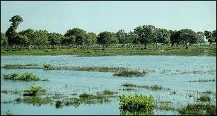 |
Walauwatta Wathurana Swamp Forest Location: 60 39’ 0 N and 800 11’ 0 E to 60 37’ 0 N and 800 13’ 0 E; 735132 N and 409730 E to 731441 N and 413409 E; near the town of Bulathsinhala in the Kalutara District, of the Western Province. Area: The swamp is spread over12 ha. Altitude: Information not available Overview: The Walauwatta-Wathurana swamp forest is located in the Kalu Ganga river basin in the southwestern part of Sri Lanka, 25 km inland from the coastal town of Kalutara. More precisely, the site is situated along a stream locally known as the Batapotte ela, which feeds the Kuda Ganga, the latter being a tributary of the Kalu Ganga. Wathurana is the most significant swamp forest in Sri Lanka. As such, it is considered a site of national importance and harbours some unique species of flora and fauna. Physical features: Wathurana is underlain by crystalline, non-fossiliferous rock of Precambrian age. The rock present is mainly charnockitic rock (the ridges), garnetiferous-quartzo-feldspathic rock (in the valleys) with sporadic quartzite bands. According to the soil classification map of the Irrigation Department and national atlas, the soil of the Wathurana area can be classified as “Red-Yellow-Podzolic soil (steeply dissected, hilly and rolling terrain)” with “alluvial soils of variable drainage and texture” in the valleys. The average monthly temperature is 27.3 oC and mean annual rainfall is 4,000-5,000 mm. Ecological features: This swamp is a late successional stage of a freshwater marsh ecosystem. The natural vegetation consists of a freshwater swamp community and patches of lowland rainforest (mainly secondary vegetation). These natural vegetation types are surrounded with managed landscapes including rubber plantations and home gardens. The swamp vegetation includes tall trees dominated by Stemonoporus moonii and Mesua stylosa and herbaceous species (Cryptocoryne spp. and Lagenandra spp.). The area is subjected to seasonal inundation, especially during the southwest monsoon period. Noteworthy fauna: The swamp and its streams harbour several species of endemic as well as locally declining freshwater fish species, including Aplocheilus dayi, Acanthocobitis urophthalmus, Channa ara, Channa orientalis, Clarias brachysoma, Lepidocephalichthys jonklaasi, Esomus thermoicos, Puntius bimaculatus, P. cumingii. P. pleurotaenia and P. titteya. The endemic amphibians include Lankanectes currugata and Rana gracilis. The aquatic reptiles include the endemic serpent Xenochrophis asperrimus. Since the swamp vegetation is bordered by lowland rainforest patches, endemic terrestrial birds such as Ocyceros gengalensis, alloperdix bicalcarata, Loriculus beryllinus, Megalaima flavifrons, Turdoides rufescens, Psittacula calthropae and Zoothera spiloptera can be found at this site. Among the noteworthy mammals, two endemic primate species (Macaca sinica and Trachypithecus vetulus) and Lutra lutra inhabit this site. Noteworthy flora: This site harbours a large number of endemic species of which two, namely Mesua stylosa and Stemonoporus moonii are found exclusively in Wathurana. Other woody endemic species in the lowland rainforest patches and locally declining species, include dipterocarps (Dipterocarpus hispidus, Shorea dyeri, Doona affinis), rattans (Calamus delicatulus, Calamus digitatus) and other trees (Cullenia ceylanica, Cullenia rosayroana, Garcinia hermonii, Garcinia quaesita, Calophyllum moonii, Vateria copallifera, Mangifera zeylanica, Schumacheria castaneifolia, Semecarpus gardneri, Semecarpus moonii, Areca concinna). Land use: Most slopes are in use as rubber or tea plantations, and abandoned chenas are common. Some places are densely vegetated with wet lowland forest (e.g Honaka forest). The valleys are 1-2 km wide, have little or no slope, and usually lie below the 15 msl (50ft) contour. Most valleys are used for paddy cultivation. Narrow streams are present at the lowest sections of the valleys along which swamp forests have developed in some locations (as in the case of Wathurana). Possible changes in land use: A reduction of water flow into Wathurana due to harmful activities such as sand mining and construction of dams could lead to a decline in the extent of the swamp area. The spread of invasive plant species such as Wormia suffruticosa could also lead to the establishment of uniform stands within the swamp area, with the replacement of native endemic vegetation. Hydrological and biophysical values: This is the only swamp forest in Sri Lanka harbouring a number of endemic floral species. Social and cultural values: Information not available Scientific research and monitoring: The YZA conducted a comprehensive survey in 2001. However, this data was not compiled and remains unpublished. Conservation education: The YZA has conducted awareness raising programmes. Recreation and tourism: Information not available Conservation measures taken: The CEA produced a conservation management plan for this site in 1994. Conservation measures proposed: The CEA produced a conservation management plan for this site in 1994. Disturbance and threats: Major threats include felling of trees and clearing of land for cultivation. The swamp area is experiencing low inundation (shortening of inundation period as well as lowering of inundation levels), possibly due to sand mining in Kuda Ganga and regulation of water flow in inter-connected networks of streams. This has also facilitated the spread of invasive alien plant species such as Wormia suffruticosa, Clidemia hirta and Lantana camara in the area. The local communities in the area over-exploit fish species for consumption. They even use poisonous substances to collect fish, which has led to the large-scale mortality of fish in streams. Need urgent action to mitigate existing threats. Land tenure: Privately owned Management authority and jurisdication: Private References: CEA/ARCADIS Euroconsult (1994i); IUCN/FAO (1997) |
| Maps |