 |
Home About Directory Conservation |
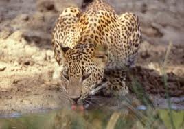 |
Wetland Cluster in Wilpattu National Park Location: 80 40’ 0 N and 790 50’ 0 E to 80 15’ 0 N and 800 10’ 0 E; 958197 N and 371643 E to 912032 N 408221 E; 30 km due west of Anuradhapura, spanning the Puttalam District and Anuradhapura District, of the Northwestern and North-central Provinces. Area: The park area is 131, 693 ha Altitude: Sea level to 152 m Overview: Situated at the extreme downstream end of the Kala Oya basin, the Wilpattu National Park, is the largest protected area in Sri Lanka, and contains significant biodiversity. The park covers 454 km2 of the Kala Oya basin and receives water from four other river systems. These rivers and rainwater sustain several types of wetlands including ancient irrigation tanks, ‘vil/villus’, water holes, estuaries and lagoons. More than 40 ‘vil/ villus’ (a type of shallow lake) are scattered in the park and these wetlands support a variety of wildlife. Each villu ranges from about 2 to 400 ha in extent, with the largest being the Periya Vila. Physical features: The main topographical feature in the park is the concentration of villus (covering ca.1500 ha), which are located in flat, basin like fault depressions on the surface and contain purely rainwater. The villus are associated with limestone sand and form the major water reservoirs for animals during the drought periods. Most of the flood plains within the park are abandoned paddy fields, and as such, most of them have altered their topography to a certain degree. Isolated flood plains are present along the Kala Oya, which is connected to the river only during the rainy season and in other times remains a flooded wetland. A large number of reservoirs are also present within the flood plain area and although most of them are not in working condition, they fill up during the rainy season. Kokkarevillu is the only brackish waterhole within the national park and in August the salinity level of the surface water is around 5 ppt. The park is situated in the low country dry zone and receives an annual precipitation of around 1,000 mm, especially during the northeast monsoons. Rain is also received during the inter-monsoon period, which extends from March to April, while an extensive drought exists between May to early September. Mean annual temperature is 27.20C. Ecological features: The floodplains in the park have in the past, been used extensively for paddy cultivation and thus the flora in these wetlands has developed subsequent to them being abandoned due to the declaration of Wilpattu National Park. Ancient irrigation tanks such as Maradanmaduwa harbour rich aquatic vegetation, including floating, submerged and emerging plants. These tanks are bordered by seasonally inundated fringing vegetation, dominated by large trees such as Terminalia arjuna, Diospyros malabarica, Pongamia pinnata and Vitex leucoxylon. The abandoned reservoirs in the floodplains are now being occupied by dry zone forest tree species and amphibious herbaceous plants typically found in floodplain wetlands. A clear zonation of herbaceous plants could be observed in the villus, determined by the receding floodwater levels. The center of the villu consists of floating (i.e. Nelumbo nucifera and Nymphaea pubescens), submerged (i.e. Hydrilla spp.) and emerging (i.e. Dopatrium spp., Potamogeton spp.) aquatic vegetation. The middle region consists of sedges (i.e. Eriocaulon spp., Cyperus spp.), while the peripheral region consists mainly of grasses (i.e. Eragrostis spp.). In Kokkare villu (brackish water), the vegetation is poor in diversity, being dominated by the exotic Najas marina, while the exposed peripheral areas are sparsely populated with Fimbristylis sp. and Typha angustifolia. The villus are surrounded by scrubland and monsoon forest with tall emergents such as Manilkara hexandra, Chloroxylon swietenia, and Vitex altissima. Around 73% of the park is made up of dense forest or scrub while the rest is more open habitat. A recent survey conducted by IUCN has documented about 180 species of plants and 290 species of vertebrates (23 fish, 17 amphibians, 61 reptiles, 149 birds, 40 mammals) from the Wilpattu National Park. Noteworthy fauna: Among the vertebrate species recorded, 20 are endemic (1 fish, 2 amphibians, 10 reptiles, 3 birds, and 4 mammals) while 31 are nationally threatened (2 fish, 2 amphibians, 14 reptiles, 7 birds and 6 mammals). The threatened and/or locally declining vertebrates include several wetland dependent species (Fish - Horadandia atukorali, Puntius ticto; Amphibians - Bufo atukoralei; Reptiles - Lissemys punctata, Melanochelys trijuga, Crocodylus palustris, Xenochrophis asperrimus; Birds - Pelecanus philippensis, Esacus recurvirostris, Leptoptilus javanicus; Mammals - Lutra lutra, Prionailurus viverrinus). Many species of large mammals in the park, including Elephas maximus, are dependant on the villus and tanks as a source of water and succulent vegetation, especially during the dry season. The birds include 24 winter visitors, including several species of waders and waterfowl. Noteworthy flora: The large trees bordering tanks and villus, including Terminalia arjuna, Diospyros malabarica, Pongamia pinnata and Vitex leucoxylon which function as important roosting sites of colony nesting water birds. The tanks and villus harbour a diversity of aquatic plants, and common species include Aponogeton natans, A. crispus, Aeschynomene indica, Elaeocharis caribaea, E. congesta, Nelumbo nucifera, Nymphaea nouchali, Nymphaea pubescens, Schoenoplectus articulatus, Scripus articulatus, S. supinus, Ludwigia adscendens and L. hyssopifolia. The dry monsoon forests around the villus and tanks harbour economically important timber species such as Diospyros ebenum, Chloroxylon swietenia and Vitex altissima. A noteworthy introduced plant that that is found in the floodplains of Pomparippu aru is Adansonia digitata (Baobab), which was introduced by the Arab traders who frequently visited Sri Lankan coastal areas via the silk route. Land use: The main purpose of the area is the conservation of biodiversity, and as such there are no major human settlements. A small fishing village is situated at Pookulum which is at the extreme north-western corner of the park. There are additional seasonal fishing camps along the coast at Kudirimalai, Palugaturai and Kolankanatte. Possible changes in land use: If the park is unused due to the prevailing security situation, illegal activities such as logging may increase, which in turn will adversely affect the existing biodiversity. Hydrological and biophysical values: The wetlands, particularly the flood plains, play an important role in minimizing flood damage to the adjacent land areas. They also serve as a breeding site for aquatic fauna such as prawns and fish, and support special assemblages of species such as Indi (Phoenix pusilla) and Karan koku. Social and cultural values: Being located in a relatively remote area away from human habitation and forming a part of the Wilpattu National Park, the wetlands of the lower basin of Kala Oya are minimally disturbed. Gange wadiya is the closest settlement to the lower basin area and it appears that poachers from this and other villages such as Karathivu and Serakkuliya visit the wetlands and associated forests frequently. The park and its surroundings are associated with much legend and history. The remnants of the early history of the country (starting from King Vijaya), especially the palace of Kuveni the jungle princess and an old harbour are found within the park. The historic Catholic church at Pallakandal is visited by several thousand pilgrims annually. The parks proximity to the well-known, archaeologically important center of Anuradhapura also supports the view that this area was a center of civilization in the past. Scientific research and monitoring: In 1969, the Smithsonian Institute carried out research on the behaviour and ecology of elephants and the plant ecology of the park. The MASL has undertaken an in depth study on the Kala Oya basin including the wetlands in the Wilpattu National Park. During 2005 and 2006, IUCN conducted a comprehensive biodiversity and archaeological study of the park, including its wetlands. Conservation education: A visitor centre/museum is situated at the park entrance in Hunuwilagama. Recreation and tourism: The national park is popular among nature lovers, particularly for those interested in leopard spotting. Due to security reasons, the park was closed to visitors from 1985 – 2003. There are 7 circuit bungalows inside the park for use by the general public. Conservation measures taken: The area was declared as a sanctuary in 1905 and upgraded to a National Park in 1938. The Wilpattu sanctuary is contiguous with the park. Conservation measures proposed: The adjacent areas of Dutch and Portugal bays have been proposed as marine extensions to the park, largely to protect the endangered Dugong dugon. Disturbance and threats: A high level of poaching and timber extraction was recorded during the parks period of closure. The release of toxic material during the decomposition of dead vegetation has been attributed to the sudden death of crocodiles in the Kokkare villu, which has been observed at the end of the drought period. The Kala Oya floodplains south of the Wilpattu national park are becoming popular illegal entertainment sites for groups of local tourists. Large groups of people have been observed camping out in the wild areas such as Monaravilluwa and engaging in activities such as hunting, fishing etc under the patronage of the locals from the area for whom it has become a source of income. During the dry season, water shortage in some tanks (e.g. Telbeepuwewa, Ulpathwewa, Nikawewa etc) of the Kala Oya basin negatively impacts the wildlife of the surrounding areas. Spread of invasive alien aquatic plants such as Hydrilla verticillata, Najas marina, Eichhornia crassipes and Salvina molesta and invasive alien fish such as Oreochromis mossambicus could cause problems to the endemic aquatic biodiversity, especially in Villus. Land tenure: State owned Management authority and jurisdication: DWC References: DWC (2004); Eisenberg and Lockhart (1972); Kotagama (1989); MASL (2002); MASL (2005); Ratz (1975) |
| Maps |