 |
Home About Directory Conservation |
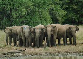 |
Yala East National Park Location: 60 42’ 0 N and 810 10’ 0 E to 60 10’ 0 N and 810 45’ 0 E; 740588 N and 518420 E to 681687 N and 582979 E; 12 km south of Arugam Bay, in the Ampara District, of the Eastern Province. Area: Park area 18,196 ha (Block 1= 17, 863.4 ha and Block II 265.3 ha), with wetlands covering 626 ha Altitude: Sea level to 90 m Overview: The two blocks of the National Park are rich in biodiversity and comprise a diversity of habitats including wetlands such as lagoons, water holes, tanks, mangrove, villus and mudflats, and natural rock pools. The main feature is the 200 ha Kumana mangrove swamp and villu surrounded by plains and a dry zone tropical thorn forest. Large saline lagoons are also present along the coast. The park is reputed for its avifauna which congregates in the mangrove and villus areas to nest, while an array of migratory waterfowl and waders also visit the wetlands. Physical features: The Kumbukkan Oya flows along the southern boundary to form the Kumana estuary and villu (200 ha) before flowing to the sea. The confluence of the Alakola Ara and other streams flow to the Kumbukkan oya and smaller streams such as the Girikula and Bagura Ara flow to lagoons. The chain of shallow, brackish to saline coastal lagoons includes Bagura Kalapuwa (154 ha), Andarakala, Itikala and Yakkala lagoons (272 ha). The lagoons are less than 2 m deep, and are subject to extensive drying out during the dry season. Bagura Kalapuwa is seasonally tidal and the Kumana villu is occasionally inundated by seawater. The Yala East National Park lies within the low country dry zone where the mean temperature is 27.30C and the average annual rainfall is around 1,300 mm. Ecological features: The park comprises of semi-arid thorn scrub with fairly large areas of dense forest comprising species such as Manilkara hexandra, Hemicyclea sepieria, Bauhinia racemosa, Cassia fistula, Chloroxylon sweitenia and Salvadora persica. A patch of mangrove is present around the Okanda lagoon. Pristine riverine forests can be found along the Kumbukkan oya. Noteworthy fauna: The main fish species caught by the fishermen from the wetlands in Yala East include Tilapia (Oreochromis spp.), and Mullet (Mugil spp.), while Channa spp. are also caught occasionally. Common reptiles inhabiting the wetlands of Kumana include Crocodylus palustris, Lissemys punctata, and Melanochelys trijuga. The Kumana Villu in particular is a hot-spot for birds. Breeding populations of rare large water birds such as Ephippiorhynchus asiaticus, Leptoptilus javanicus, Platalea leucorodia and Esacus recurvirostris inhabit the villu. Several species of migratory waders (families Scolopacidae and Charadriidae) and waterfowl (Family Anatidae) visit the shallow lagoons and mudflats. The wetlands are also visited by mammals such as Canis aureus, Sus scrofa, Elephas maximus, Lutra lutra and Prionailurus viverrinus to feed on aquatic plants and/ or animals. Noteworthy flora: The trees in the Kumana villu are dominated by Sonneratia caseolaris, while the reeds are dominated by Typha angustifolia. Patches of Achrosticum aureum are also present in the villu. The riverine forest along the Kumbukkan oya is dominated by large trees of Terminalia arjuna. Aquatic species such as Ludwigia spp., Nelumbo nucifera, Nymphaea pubescens, Aponogeton spp. and Neptunia oleracea are common in ponds and tanks. Land use: Biodiversity conservation Possible changes in land use: Information not available Hydrological and biophysical values: The sand bars breach annually with the heavy rains in November and December releasing the excess water and thereby preventing flooding in the upland areas. This phenomenon also assists many fish and crustaceans to spawn. Social and cultural values: This area was part of an ancient civilization dating back to the 3rd century BC. At the base of most rock outcrops are caves, some with rock inscriptions of the first and second century BC. Scientific research and monitoring: The CBC conducts annual censuses of waterbirds. Conservation education: Information not available Recreation and tourism: The park is popular among nature lovers, especially for bird watching. Due to security reasons, the area was closed to visitors from 1985 –2003. Two bungalows and a campsite are available for overnight stay. Conservation measures taken: The Kumana villu was initially declared a bird sanctuary in 1938 and is now included within the Yala East National Park. Block II of the Park was established in December 1969, followed by Block I in January 1970. The Park is contiguous with Ruhuna (Yala) National Park. Conservation measures proposed: IUCN has proposed to declare the Kumana wetlands as a Ramsar wetland site. Disturbance and threats: Poor land use practices in the upland areas of rivers and streams has led to siltation of the lagoons. Poaching, mainly for game meat, but also occasionally for leopard skins is known to be common. Illegal timber extraction also takes place within the park. Land tenure: State owned Management authority and jurisdication: DWC References: DWC (2004); Fauna International (1993); Kotagama (1989) |
| Maps |