 |
Home About Directory Conservation |
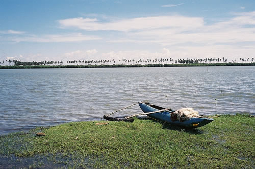 |
Rekawa Lagoon Location: 60 5’ 24 N and 800 45’ 36 E to 60 2’ 48 N and 800 52’ 0 E; 672423 N and 472337 E to 666891 N and 485245 E; about 200 km south of Colombo, in the Hambantota District, of the Southern Province. Area: 250 ha Altitude: Sea level Overview: Despite being traditionally viewed and referred to as a lagoon, Rekawa is a shallow brackish water estuary, receiving freshwater from the Kirama Oya and connected to the sea via two outlets, one of which is natural in Kapuhenwela and the other a man made canal in Medilla. The presence of mangroves, along with coral reefs and five species of globally threatened marine turtles in nearby coastal waters gives high biological value to the lagoon and surrounding environment. Fisheries are the most important livelihood of the rural village community in the vicinity of the wetland. Lack of employment opportunities has lead to increased dependency on the lagoon resources. Physical features: The metamorphic rocks in the Rekawa area are Precambrian in age and areas near the river are Miocene limestone, with alluvial soil beds. The coastal plain has been formed primarily through the erosion of crystalline rocks, and more recent sedimentary deposits. The wetland lies in the intermediate zone between the dry and wet climatic zones, with an average rainfall of about 2,000 mm per year. The average temperature ranges from 26.6 – 27.20 C. The area is subjected to strong winds (23 km /hr), especially from June to September. The winds and constant wave action on the shoreline have given rise to depositional sand dunes and leads to periodic closure of the lagoon mouth. The salinity in the lagoon basin varies between 0 – 10 ppt. The lagoon receives most of its water from the inland watershed draining the Kirama Oya, whose water is mainly used for irrigation through 19 anicuts, before reaching the lagoon. Rekawa Oya, which is a small stream, also provides water to the lagoon. Water from the wetland reaches the sea through a sand bar breach, located at the natural lagoon mouth, on the south western end of the lagoon. Ecological features: Mangrove and scrub forest surround the lagoon, which is bound on the seaward side by a broad, sandy beach 10 km long. Landward of the lagoon is a large tract of paddy fields about 500 ha in extent, most of which have been abandoned. The mangrove cover has increased from 100 ha in 1984 to 200 ha in 1994 due to sedimentation, but the quality of mangroves has decreased. The mangrove communities around the lagoon include Lumnitzera, Ceriops and Avicennia dominated stands. The 2004 Indian Ocean tsunami had a major impact on the mangroves growing along the sides of the Kapuhenwela outlet and canal as a result of the tsunami wave being funnelled in through the estuary. The damage extended 500m inland from the estuary mouth as the narrow mangrove strip directly facing the wave was unable to withstand the force and was uprooted. No structural damage was seen in either coconut land or the mangroves surrounding the Rekawa lagoon. Towards the beach, littoral species such as Bryophyllum pinnata and Cyperus rotundus can be found. The halophytes together with Bacopa monniera and Ipomoea aquatica are found close to water. 37 fish species, 9 crustacean species and 104 bird species (including 15 migrants) have been recorded from the lagoon environment. Off the northeastern side of the Rekawa headline there is a shallow fringing reef about 100- 150 m wide and 300 m long. Thirty-five species of stony corals and 138 species of reef and reef associated fish have been recorded from the reef. The sandy beach provides an ideal nesting site for five species of marine turtles. Noteworthy fauna: The common finfish in fish catches include Anabas testudineus, Channa orientalis, Etroplus suratensis, Hyporanphus limbatus, Oreochromis spp. and Anchoviella spp. Three species of economically important prawn are found in the lagoon, namely, Penaeus indicus, Metapenaeus monoceros and Penaeus monodon. The adjacent beaches also provide favourable nesting grounds for all five species of globally endangered marine turtles that visit Sri Lanka, although no recent records of Eretmochelys imbricata nests have been found. The most common nesting species is Chelonia mydas. Noteworthy flora: The mangrove communities are dominated by Lumnitzera racemosa, Ceriops tagal and Avicennia officinalis. Land use: Lagoon fishing is practiced by around 10% of the population while a much larger number is involved in sea fishing. Illegal sea coral mining also takes place. Human settlements and agriculture are the main terrestrial land uses in the lagoon vicinity. Possible changes in land use: The development of a causeway across the narrow section of the lagoon at Kapuhenwala has reduced the natural exchange of sea and lagoon water and increased the sedimentation. This has lead to increased mangrove cover and decreased fishery potential which may impact on fisheries in the future. Establishment of a new settlement area in the northern border of the lagoon subsequent to the tsunami could lead to further sedimentation and clearance of mangrove areas as well. Coral mining has also led to severe erosion of the coastline at Rekawa. Hydrological and biophysical values: Manual breaching of the lagoon mouth during the rainy season controls flooding. Opening of the mouth is also important to the shrimp fishery, as the shrimp larvae enters the lagoon during this period. Social and cultural values: The lagoon area has nearly 5400 people comprising of 1200 families, out of which 50% are engaged in sea and lagoon fishing and the remainder in agriculture. However, due to the high salinity of the soil, most land in the Rekawa area cannot be used for paddy cultivation. Their incomes tend to be low by national standards and due to high levels of unemployment, the community depends on the lagoon for survival. The lagoon hosts a community of traditional fisher folk engaged in a seven month shrimp fishery using traditional non-mechanical boats, nets and various traps. This community has resisted the development of commercial prawn farming in the area. Scientific research and monitoring: NARA maintains a research station and regional office at Rekawa and conducts research on the lagoon fishery. The TCP, has established an education and research centre at Rekawa in 1994, and implemented several research programmes on turtles that visit the Rekawa beach for nesting. Conservation education: Since 1996, the TCP has been conducting community based marine turtle nest protection programmes employing previous nest poachers in the area. The DWC is also involved in similar activities. Recreation and tourism: The Rekawa area has potential for nature-based tourism, which has not yet been fully achieved. The TCP conducts nature based tourism programmes on the in-situ conservation of marine turtles in the adjoining beach area. Recently, the USAID funded SCOTIA selected Rekawa lagoon area to promote ecotourism. Conservation measures taken: A Coastal Environmental Profile of Rekawa lagoon was prepared in 1990 by the CCD which initiated the Rekawa SAM process under the CRMP in 1993, with a management plan being prepared in 1996. The Rekawa Lagoon Fishery Cooperative Society (RLFCS) has been organized and registered to carry out the management plan. Unfortunately, after the CRMP activities ended in the 1990s, the RLFCS ceased to operate. In 1999, the Rekawa lagoon fisheries management area regulations were gazetted under the FARA. In 2001, Rekawa Lagoon Fisheries Management was gazetted and in the same year it was rechristened as the Rekawa Lagoon Fisheries Management Authority. Reduction of destructive fishing practices was successful, especially with respect to fishing kraals and net size, largely as a result of the work of the RLMC through a GTZ funded project. The TCP has been operating in the area since the mid 1990s and has promoted in-situ turtle conservation together with DWC and NARA as well as introducing new livelihoods to women coral miners in the area. In 2000, the Survey Department demarcated the boundaries of the mangroves in this area, while NARA and local CBO’s have carried out mangrove restoration activities around the lagoon over the past decade. The DWC has recently declared the Rekawa beach (4 km stretch) as a sanctuary, to conserve marine turtles. Conservation measures proposed: Several conservation measures have been proposed by the ADB funded CRMP and GEF funded RUK Project. These include the development of alternative livelihoods for lagoon resource users and the implementation of a zonation scheme and sustainable use plan for the mangrove resources, restoration of degraded mangrove stands, and restocking of the lagoon with shrimp. Disturbance and threats: Reduced freshwater flow due to the numerous irrigation schemes in the watersheds, reduced sea water flow and increased sedimentation due to construction of several causeways, particularly at Kapuhenwala have resulted in reduction of the lagoon area from 339 ha in 1983 to 250 ha in 1992. The use of drift nets have reduced the natural recruitment of shrimp and movement of fish, while degradation of lagoon water quality due to pesticides and insecticides used in agriculture and removal of mangrove for hotel construction have destroyed habitats and affected fisheries. The December 2004 tsunami destroyed a few mangrove stands near the lagoon mouth. The invasive alien Opuntia dillennii is found extensively and some plants got uprooted and transported to inland areas during the tsunami. The propagules have now started to colonise new areas and could potentially pose a problem. The coral reef closer to the lagoon has been degraded due to illegal but extensive coral mining. Land tenure: The lagoon and its environs are state owned while home gardens and houses are situated on privately owned land. Management authority and jurisdication: The Tangalle DS has jurisdiction over the area. The Rekawa Lagoon Fishermen’s Cooperative Society, a voluntary organization manages the lagoon fishery along with the Fisheries Department. References: Clemett et al. (2004); Ekaratne et al. (1998); Ganewatte et al. (1995); IUCN (2000); IUCN (2003d); Kapurusinghe (1998); Lowry et al. (1997); NARA (1997); Perera et al. (2004); Perera et al. (2005); Rekawa Special Area Management Coordinating Committee (1996); Southern Development Authority of Sri Lanka/ CCD (2000b) |
| Maps |