 |
Home About Directory Conservation |
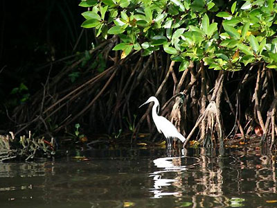 |
Muthurajawela Marshes Location: 70 7’ 0 N and 790 51’ 0 E to 70 0’ 0 N and 790 56’ 0 E; 786804 N and 373005 E to 773883 N and 382179 E; 10 km North of Colombo in the Gampaha District, of the Western Province. Area: 2,569.2 ha (Sanctuary and buffer zone) Altitude: Sea level Overview: Muthurajawela is the largest saline peat bog in Sri Lanka, and together with the Negombo estuary forms an integrated coastal wetland ecosystem spanning 6,232 ha. Estimated economic value of the wetland is around Rs 726.5 million per year and the benefits mainly come in the form of flood attenuation and wastewater treatment. The marsh supports livelihood activities such as fishing and to a lesser extent agriculture. The location of Muthurajawela in a rapidly developing and highly populated urban area makes it an extremely valuable, yet vulnerable ecosystem. Physical features: The marsh is located within the low country wet zone and is influenced by the southwest monsoon. The highest rainfall is received during the inter-monsoon periods in April and May, and in October and November, with an annual rainfall between 2,000 – 2,500 mm. Average annual temperature is around 270 C. The soil is a uniform, potentially acidic sulphate, and the land is poorly drained with a peaty substrate which is saturated for almost the whole year. The marsh receives water from the Kelani river and the Dandugam oya stream. Ecological features: The marsh plant community is unstable and represents one of the final stages of succession towards dry land formation. High-levels of human disturbance have lead to significant change in the composition of dominant plant species over the last ten years, which in turn had an effect on the faunal composition. One hundred and ninety four species of flora belonging to 66 families are distributed over seven major vegetation communities (marsh, lentic, reed swamp, short grassland, shrub land, stream bank and mangrove swamp). The shrub land harbours the highest number of species (115), while the mangrove forest and stream bank/ riparian type consist of the lowest (23). The vertebrate fauna includes 40 species of fish (4 endemic and nationally threatened), 14 species of amphibians, 31 species of reptiles, 102 species of birds (including one endemic and 19 winter migrants), and 22 species of mammals. Noteworthy fauna: Out of the 209 species of vertebrate fauna documented, 17 (9%) are endemic, while 26 (12%) are nationally threatened. The endemic fish species include Puntius singala, Esomus thermoicos,Channa orientalis, Clarias brachysoma and Aplocheilus dayi. Among the amphibians, Bufo atukoralei, Lankanectes corrugate, Rana gracilis and Polypedates cruciger are endemic to Sri Lanka. Among the reptiles, Varanus salvator is the most common, while rare species include Crocodylus porosus and Achrochordus granulatus. Rare birds in Muthurajawela include Porzana fusca and Rostratula benghalensis, while the migratory Marsh Harrier (Circus aeruginosus) is fairly common in the southern part of the marsh. Rare mammals in the marsh include Lutra lutra, Prionailurus viverrinus and the primate Loris tardigradus. The most common odonates include Neurothemis tulia and Rhyothemis variegata. The giant freshwater prawn (Macrobrachium spp.) also inhabits the marsh. Noteworthy flora: Within the recorded flora, one endemic (Phoenix zeylanica), and three nationally threatened (Aponogeton natans, Nypa fruticans, Caesalpinia crista) species occur in the marsh. The mangrove in the northern border of the marsh is dominated by Avicennia marina and Rhizophora mucronata. The lentic flora in open water bodies is dominated by Nymphaea stellata and Eleocharis dulcis. The riparian vegetation includes Pandanus tectorius, Cerbera manghas and Syzygium caryophyllatum. The reedbeds consist of Phragmites karka. Land use: Historically, the marshes were used for paddy cultivation but cultivation was abandoned due to salt-water intrusion. Starting from the 15th century, the marsh system has been altered, and a variety of canals, drains, bunds, sluices and culverts present evidence of various attempts to manage water flow, combat flooding and prevent salt-water intrusion, in addition to the development of the waterways for transportation of goods. An estimated 700 households live in settlements within the marsh, with the majority of houses being temporary structures. A resettlement village founded in 1994 in the southern part of the marsh comprises of around 240 families. Agricultural activities are limited due to poor soil conditions, but around 90 ha are planted with coconut, bananas and vegetables. Possible changes in land use: Since the 1970s land filling and reclamation of the marsh for industry, infrastructure and human settlements has accelerated. Over half of the marsh population are squatters and about three quarters of landholdings are unauthorised. Recently the marsh was segmented due to the construction of the Colombo-Katunayake highway Hydrological and biophysical values: Muthurajawela receives and retains high loads of domestic and industrial wastes and sediment from both surrounding and upstream areas. Wetland plants facilitate sediment deposition, before water enters Negombo lagoon. The plants also act as a filter for through-flowing waters, and assist in the removal of nutrients and toxic substances. During the rainy season the wetland acts as a retention area for run-off from surrounding higher grounds and floodwaters from Dadugam Oya, Kalu Oya and Kelani Ganga. The maximum water storage capacity of the marsh is 11 million cubic meters, with a maximum discharge of 12.5 cubic meters per second and a retention period of more than 10 days. By maintaining surface, near surface and possibly groundwater levels, the marsh also plays a major role in the local freshwater supply. These functions are particularly important for local households, as many depend on shallow-dug wells. The overall economic value of the wetland has been estimated to be around Rs 726.5 million per year. Social and cultural values: Around 5,000 people live in or directly adjacent to Muthurajawela marsh, although the majority are engaged in low-paying manual labour activities. A few traditional fishing families are involved in small-scale commercial and subsistence fisheries in the canals, the Dandugam Oya and marsh-lagoon transition zone.The canals running through the wetland were developed and used for transportation of goods during the Dutch period. Scientific research and monitoring: The wetland was studied thoroughly under the Dutch funded Wetland Conservation Project executed by the CEA in 1993. IUCN has also conducted biodiversity surveys and an economic valuation of the wetland. Conservation education: The marsh provides a field laboratory for diverse studies at both school and university level. Sri Lankan universities as well as several foreign universities have conducted graduate and post-graduate level studies at this site. A visitor centre was set up by the CEA in 1996 and is now managed and operated by the Muthurajawela and Negombo Lagoon Development Foundation. Recreation and tourism: Local and foreign tourists regularly visit the wetland for sight-seeing and bird watching. In 1996 a visitor centre, “The Marsh” was established by the CEA under the Wetland Conservation Project. With attractions such as boat rides, a model fishing village, a restaurant, shop and meeting facilities, it became popular amongst school children and tourists. It was closed down in mid 2001 due to the construction of the Colombo-Katunayake highway and a temporary centre was set up near the Hamilton Canal. A new permanent visitor centre was established in 2003. Conservation measures taken: In 1989 as a result of growing concern about the degradation of the ecosystem, the government froze all public and private sector developments within the marsh until the preparation of a master plan for sustainable resource use. In 1991, the Greater Colombo Economic Commission prepared the Master Plan for the Muthurajawela marsh and Negombo Lagoon wetland complex, which included a land use strategy based on the wetland being divided into zones for conservation, industrial development, and residential development. A detailed plan for the conservation zone was prepared following approval from the government in 1992. In 1996, 1,284.45 ha of the northern section of Muthurajawela were declared a Sanctuary under the FFPO. In 2004, a buffer zone (the area between the conservation zone and mixed urban zone) of 285.4 ha was protected as an EPA under the NEA. This was the first site to be declared an EPA under this act. Conservation measures proposed: A biodiversity status profile prepared by IUCN, and the conservation management plan prepared by the CEA have made several recommendations for conservation. These include upgrading the northern part of the Sanctuary to a higher protected area category, clarification and documentation of the legal status of land ownership, restoration of degraded habitats, initiation of programmes to manage the spread of invasive alien species, and rehabilitation of the canal network to ensure adequate water seepage to keep the peaty soils moist. Disturbance and threats: Illegal reclamation of land for housing, dumping of garbage, chemical pollution and eutrophication (due to agricultural fertilizers and pesticides, residue from illegal breweries) are major threats to the wetland. Direct exploitation of natural resources such as poaching and cutting of trees and reeds are also major issues. The spread of invasive alien plant species such as Annona glabra, Eichhornia crassipes, Pistia stratiotes and Salvinia molesta has affected the native plant communities in the wetland. Unmanaged domesticated animals (buffalo, cattle, pigs, goats, dogs and cats) pose a serious threat to native flora and fauna. Need urgent actions to mitigate existing threats. Land tenure: The sanctuary area is state owned while the surrounding lands are either owned by the church, or privately owned. Management authority and jurisdication: DWC References: Bambaradeniya et al. (2002c); CEA/ARCADIS Euroconsult (1994f); CEA/ARCADIS Euroconsult (2003); Emerton and Kekulandala (2002); The Government of Sri Lanka (1996) |
| Maps |